Your browser is out-of-date!
For a richer surfing experience on our website, please update your browser. Update my browser now!
For a richer surfing experience on our website, please update your browser. Update my browser now!
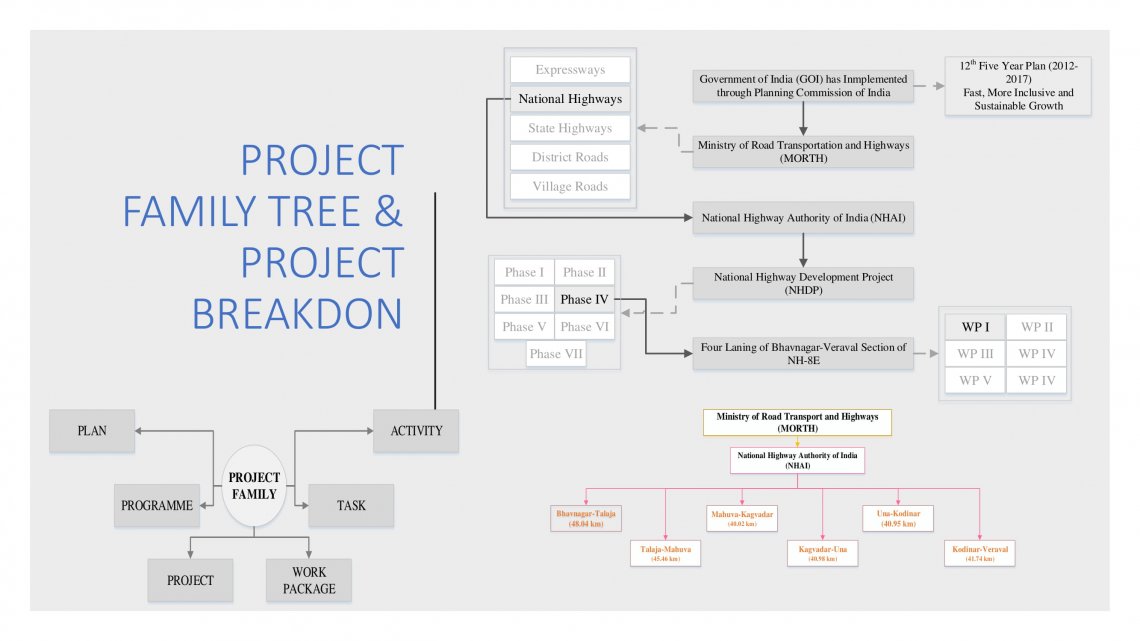
The National Highways Authority of India (NHAI), Government of India under Ministry of Shipping, Road Transport and Highway (MOSRT&H), has decided to take up the development of various National Highway Corridors for augmentation of capacity and for safe and efficient movement of traffic by widening to four/six lanes. Accordingly, NHAI has proposed to implement the development projects for few selected sections/corridors. The alignment starts at Bhavnagar (km 03.200) and extends up to Dwarka (km 473.000) for a length of approximately 470 km in the State of Gujarat. After the discussions on the first length, the project has been extended from Dwarka to Okha for a length of approximately 30 kms that is presently State Highway. The present study corridor is the existing National Highway – 8E passing through five districts of the state of Gujarat namely, Bhavnagar, Amreli, Junagadh, Porbandar and Jamnagar. The project road is approximately now 500 km long. It starts at Bhavnagar, runs almost parallel to the southern coast of Gujarat and ends at Okha. Initially, the highway was up to Veraval and continued northwards as NH-8E from here. Later on, a link was made to Chorwad from NH-8E which continues as NH-8E up to Dwarka. From Dwarka to Okha, the existing highway is SH-25. The project road passes through many towns like Trapaj, Pipavav, Una, Somnath, Veraval, Madhavpur and Porbandar, Dwarka before it ends at Okha. It also passes through many major villages en route. The corridors selected for the project are indicated below: 1. Bhavnagar (km 3.200) to Dwarka (km 473.000) section of NH – 8E.