Your browser is out-of-date!
For a richer surfing experience on our website, please update your browser. Update my browser now!
For a richer surfing experience on our website, please update your browser. Update my browser now!
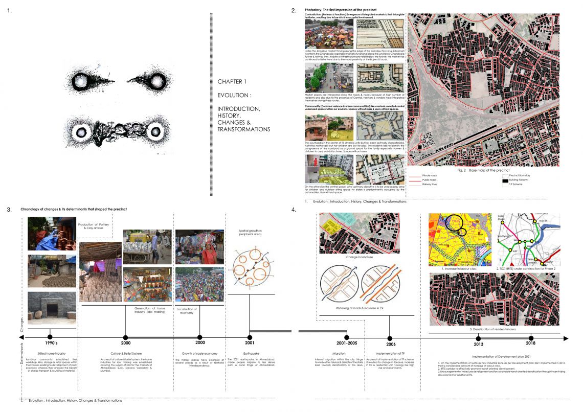
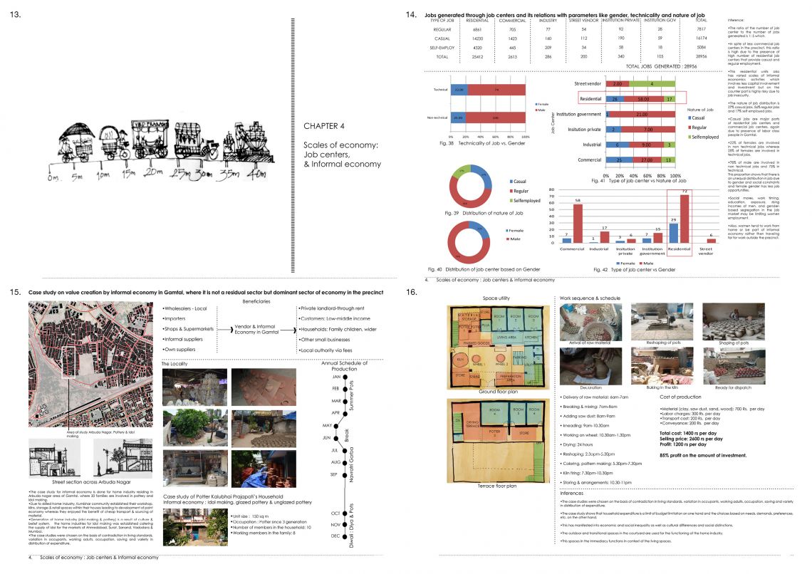
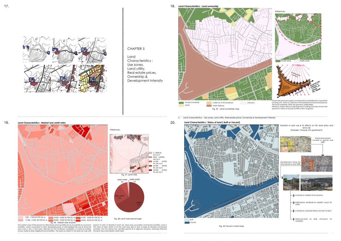
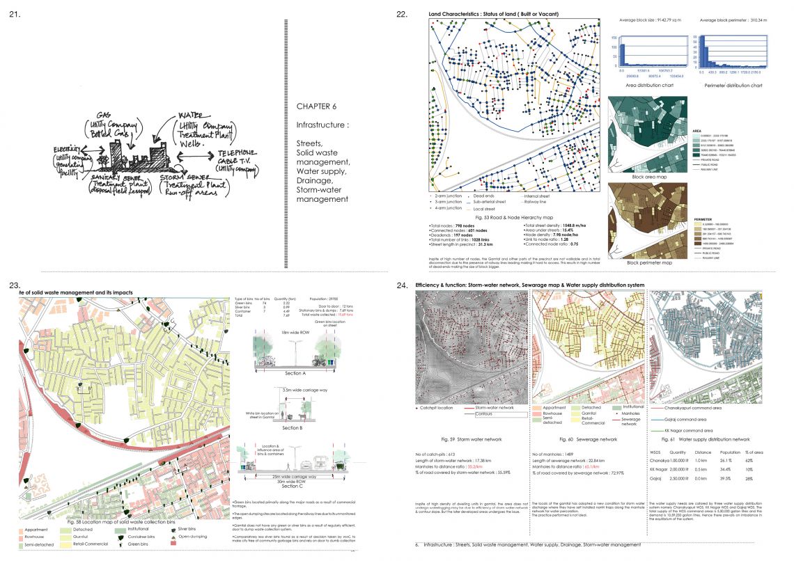
Chandlodia is a densely packed urban block located towards northwestern part of Ahmedabad. The precinct, in itself, gives a very different perception of neighborhood compared to what exists today in Ahmedabad which has planned outdoor plazas, transit corridors, gardens, and wider lane. The conceit that sets this standing situation is the presence of 80-year-old Gamtal and tripartite railway lines. New residential areas have distinctively coexisted with Gamtal in its immediate edges. The overall photo-story of the area brings in the image of users without spaces and spaces without users. The public realm on analyzing is neither public nor private, neither internal nor external, neither part nor whole. Due to the density of the settlement, these enclosures are tight and bounded on all sides. Market spaces are integrated inside the narrow lanes, streets, and alleys. In understanding this part of the city, the framework is structured around the existence, impact, connectivity, accessibility, conflicts in the implementation of new trends of development around Gamtal, its implications on itself and its immediate environs. • To begin with, the precinct is analyzed through the lens of Gamtal by understanding the pace of its evolution in terms of transformation. This Evolution is furthermore studied in terms of physical transformations occurred in past 20 years through satellite imagery, documenting the transformations through residents point of view and mapping chronology of transformations through its determinants. • The study is followed by getting into the prevailing distinct & prominent characters of the Gamtal. It has remained unchanged in the past years and maintained its character in terms of built form, social organization, locality, neighborhood, the predominance of primary relations, lifestyle and socio-economic status. In the following chapter, Building typology, housing, and housing spectrum are mapped to analyze the physical characteristics of the built-form, density, and typology along with different survey based categorization based on housing situations. • This discussion is followed by the interlink of the choices and trade-offs people make. Analysis of travel behavior is done to understand how the family participates in society. In this precinct, there are two non-observable specialization extremes. At one extreme we have the non-specialized household. It does everything for itself, and no travel is required. Ultimate specialization is the other extreme; travel is required for all things. The purpose of the study is to know the modern day equation of work, travel & living in a settlement like Gamtal in an Urban area like Ahmedabad. • As said city is a marketplace, similarly the precinct in itself is a job center & creates multiple jobs. To sustain the day to day needs, human being themselves are dependent on one another and Gamtal hugely houses a big number of service class people. Jobs generated through Scales of Economy, job centers and its relations with parameters like gender, technicality, and nature of the job is understood. A case study is done on value creation by the informal economy in Gamtal, where it is not a residual sector but dominant sector of the economy in the precinct. • After the choice based trends, trade-offs and patterns of the precinct are mapped, studied and analyzed; to understand the physical form and structure of city, land characteristics is one of the most important aspects. The following questions were raised like, Parameters like use zones, land utility, market & jantri prices, land ownership and status of urban land is mapped to understand the intensity of development in the precinct. The distinct presence of Gamtal (Village revenue boundary) which has its own limitation on land usage as it can not be regulated by the Urban local body. These characteristics are analyzed keeping Gamtal in the picture. • The documentation of infrastructure in a city is of equal importance for understanding the physical components of the city. Road network, Solid waste management, Water supply, Drainage, and Storm-water management are studied as a part of the infrastructural network. This physical components of interrelated systems provide essential services to enable, sustain and enhance societal living conditions. These services are also analyzed in terms of its accountability, equability, and sustainability taking in the account of population growth, urban sprawl, and terrain. • The precinct, in itself, gives a very different perception of Urban spaces compared to what exists today in Ahmedabad which has planned outdoor plazas, transit corridors, gardens, and wider lane. The conceit that sets this standing situation is the presence of 80-year-old Gamtal and tripartite railway lines. The public realm on analyzing is neither public nor private, neither internal nor external, neither part nor whole. Due to the density of the settlement, these enclosures are tight and bounded on all sides. Market spaces are integrated inside the narrow lanes, streets, and alleys.