• Home
  • FP
  • UR3005
  • RiverBANK : Bank of food, land and biodiversity

Shrayana Ray

UR3005

RiverBANK : Bank of food, land and biodiversity

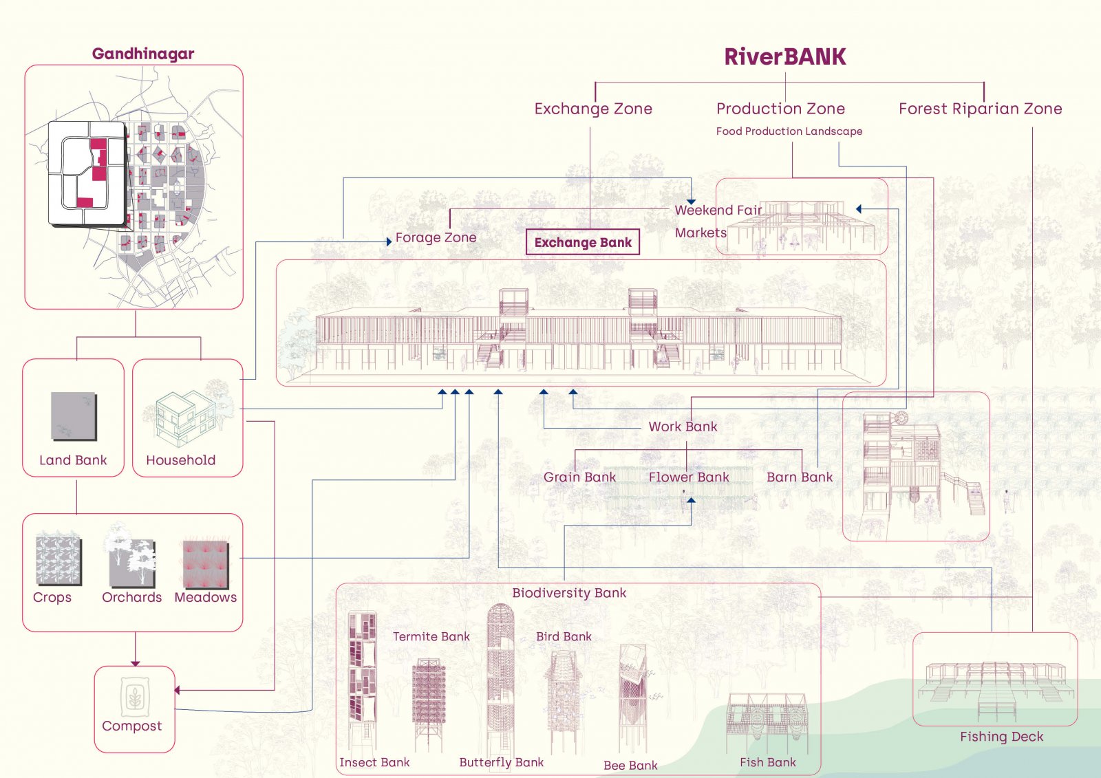
The project RiverBANK is an integrated system of productive agro-based network that lends spaces to the community for growing food (at the river-side site and in the city). The main design is at the river edge where the sloped terrain is re-structured into terraced spaces for the community to grow food. The primary and secondary trail network is designed through the entire bank and different blocks are divided into zones for the cultivation of different types of food. This entire food zone is supported through an array of radical infrastructures designed for different biodiversity species integral to creating an ecosystem of resilience and natural practices. These products/services derived from the RiverBANK can be exchanged through community currency and bartered across the city to fulfill the daily requirements of people. If not the entire supply of food, a small percentage can be met through this agro-based development. Many marginal and lower-income groups can have access to healthy food and nutrition. The riverbank creates a productive food flow network into the city by utilizing under-utilized land and making resources available in close proximity. 

View Additional Work
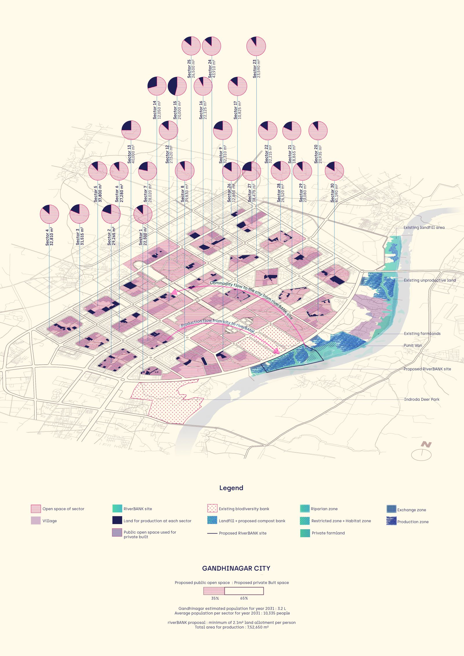
Report Content

Gandhinagar is sparsely populated with an expected count of 3.1L people for the year 2031 and 35% of the land has public ownership. Yet, the city lacks resilient social infrastructures and a sense of community. The food supply of the city is met through the agricultural farmlands outside the city which thereby is responsible for the condition of the local economy derived from the dependency on the global forces. Thus, the city needs more local control and decision-making power. The riverBANK system provides a minimum of 2.1m2 land for production to every citizen of Gandhinagar in their respective sectors and the riverbank of Sabarmati becomes the social core of exchange of the produce.

The above is an experiential comic describing how a Gandhinagar resident's daily life would fit in with the RiverBANK system.

The people can pool and get their land allotments in the RiverBANK site for production of their choice. The whole site is divided into three zones namely the Upland Exchange zone, Midland Production zone and Lowland Riparian Forest Zone. The exchange zone becomes the hotspot of social interaction as the produce from the city's land banks as well as from the Production zone is exchanged here. The above Concept diagram depicts how the entire system is linked together.

Existing Site conditions and design development of the RiverBANK. These are the key reasons for introducing the riverBANK concept and design. Since the land is public yet inaccessible and unproductive, it has a lot of scopes to make use of it and generate revenue, a system of exchange, and a sense of self-reliance.

Proposed L SCALE PLAN - The 85m wide J road and the street edge (10m wide) has been designed to accommodate traffic as well as to make it a lively edge for the three exchange banks to work. This exchange zone becomes the place of maximum footfall. The production zone has a series of land banks used for different food production connected with networks of 1.5m wide tertiary trails. The work banks are situated at uniform intervals to support the production. The meandering forest trail and the riparian forest zone have the existing preserved forest and the biodiversity support banks.

S SCALE PLANS - The exchange zone zoomed-in plan shows the J road (85m wide), the exchange bank with the shop fronts facing the street edge, the forage zone, and the secondary road (8m wide) behind the exchange bank. The production zone zoomed-in plan shows the Work Bank for Grains, situated at the oilseed farms. One can bring their farm’s harvest and process it further for consumption. The Riparian forest zone zoomed-in shows the fishing deck to go down the Sabarmati River and the attached fish bank to support the marine life.

SECTION - The section has been cut across the whole site starting from the J road to the river. It shows the varying landscape from forage zone, stepped farms to the riparian forest. Zoomed-in sections of the architectural inserts i.e. the banks have been detailed out.

View of the RiverBANK from J Road.

View of the Biodiversity Banks in the Riparian Forest Zone. The view consists of the Bird Bank (right), the insect Bank (left) and the Butterfly Bank (centre). The skin of the infrastructures have been designed to support the fauna and act as their habitat.

Planting palette for the three zones.