Ishita Rakesh Singh

UR2008

An Oasis of Hope

Region & Speculation-
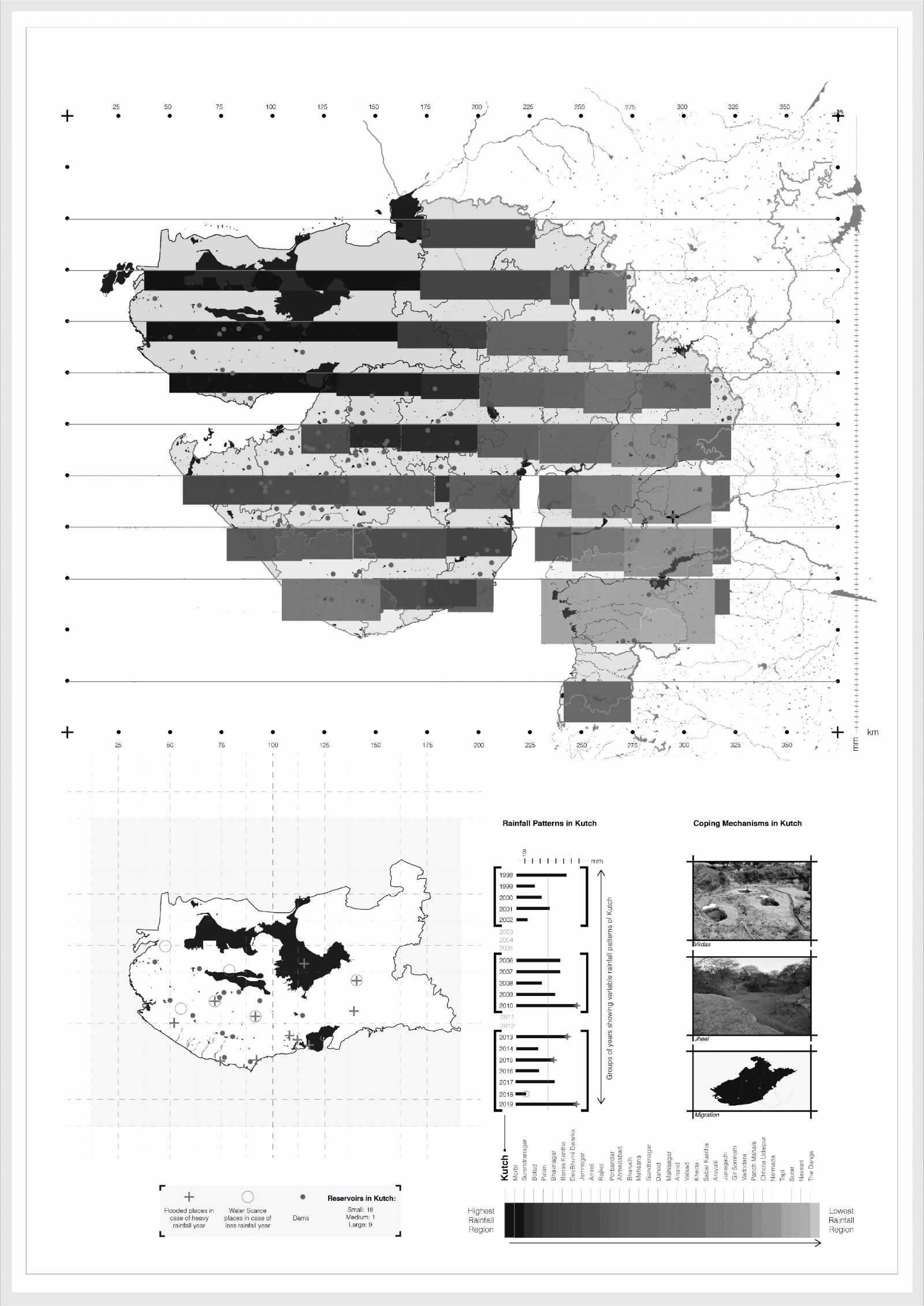
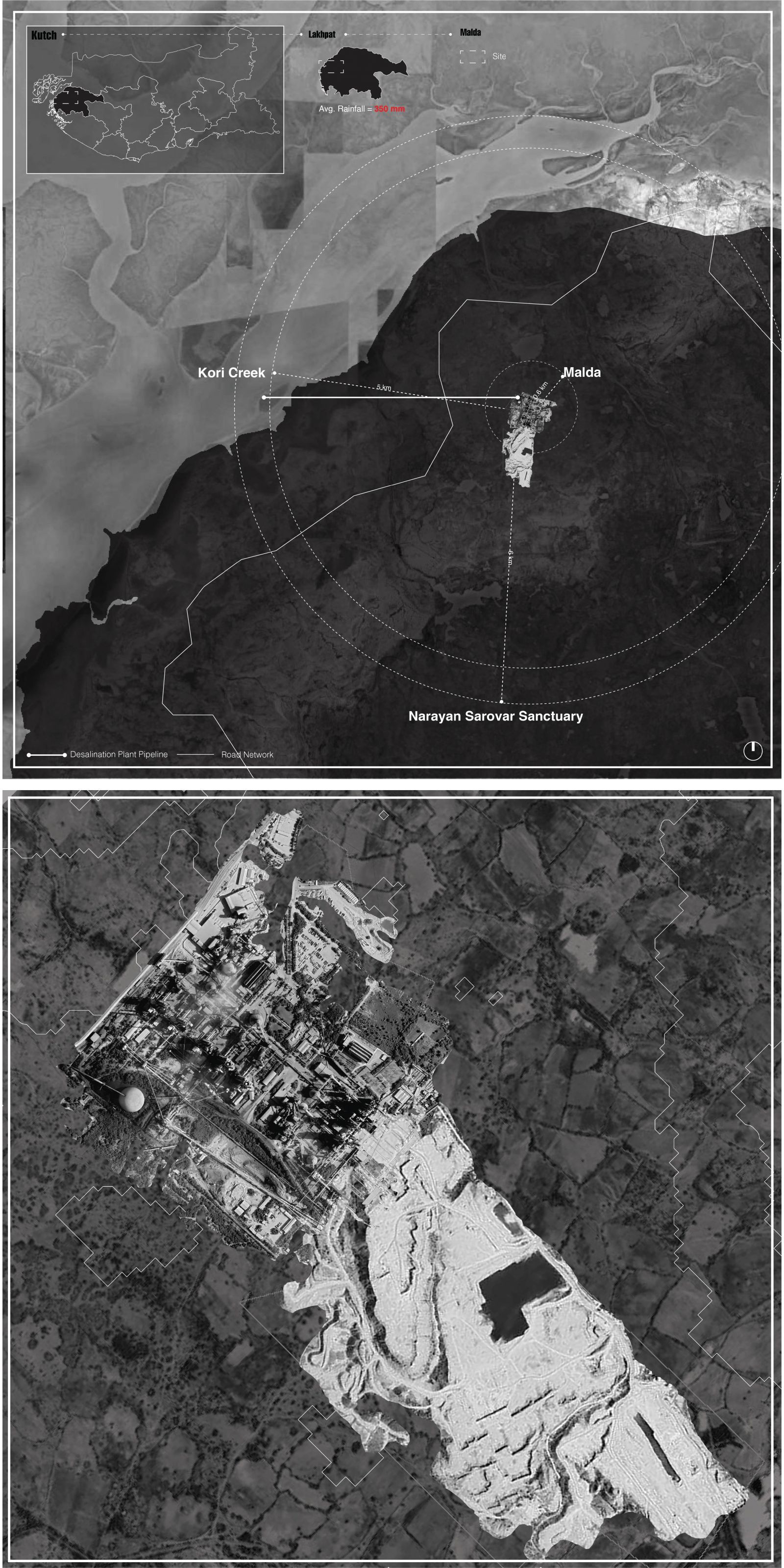
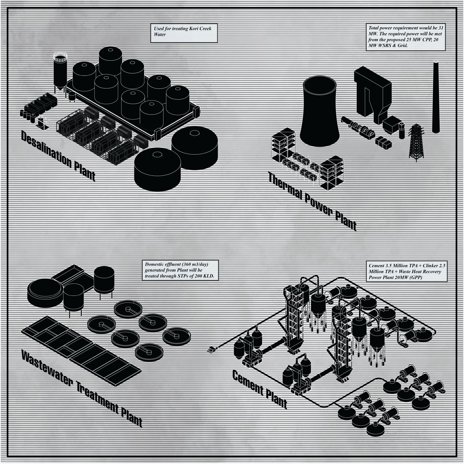
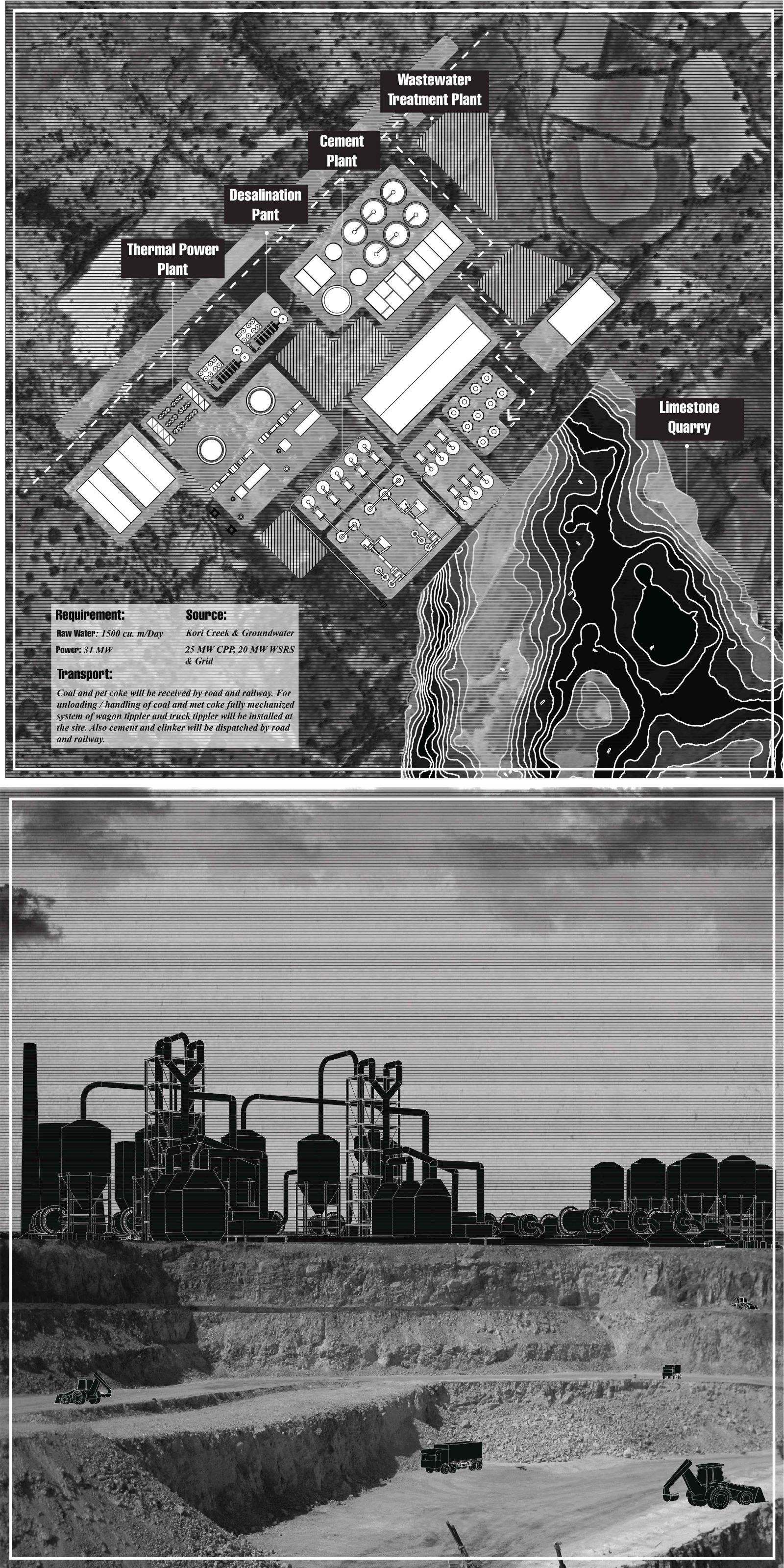
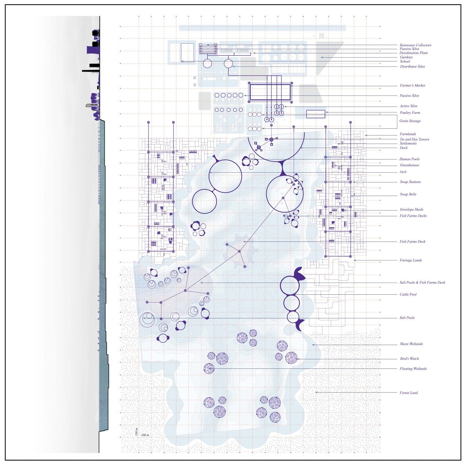
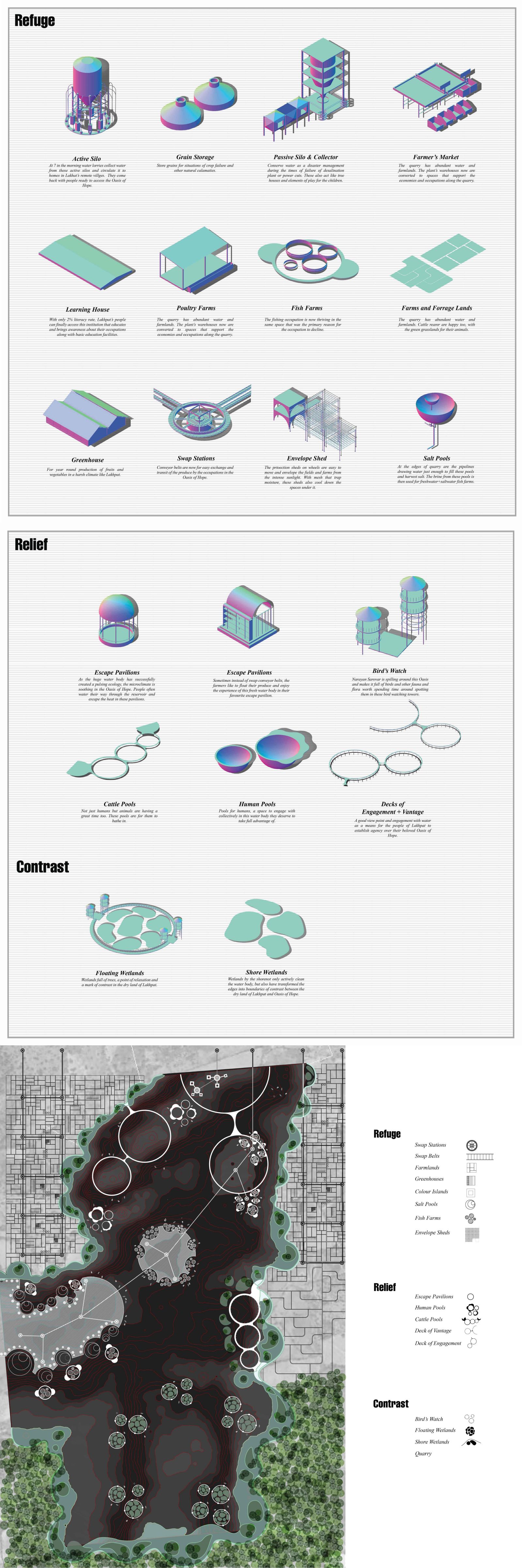
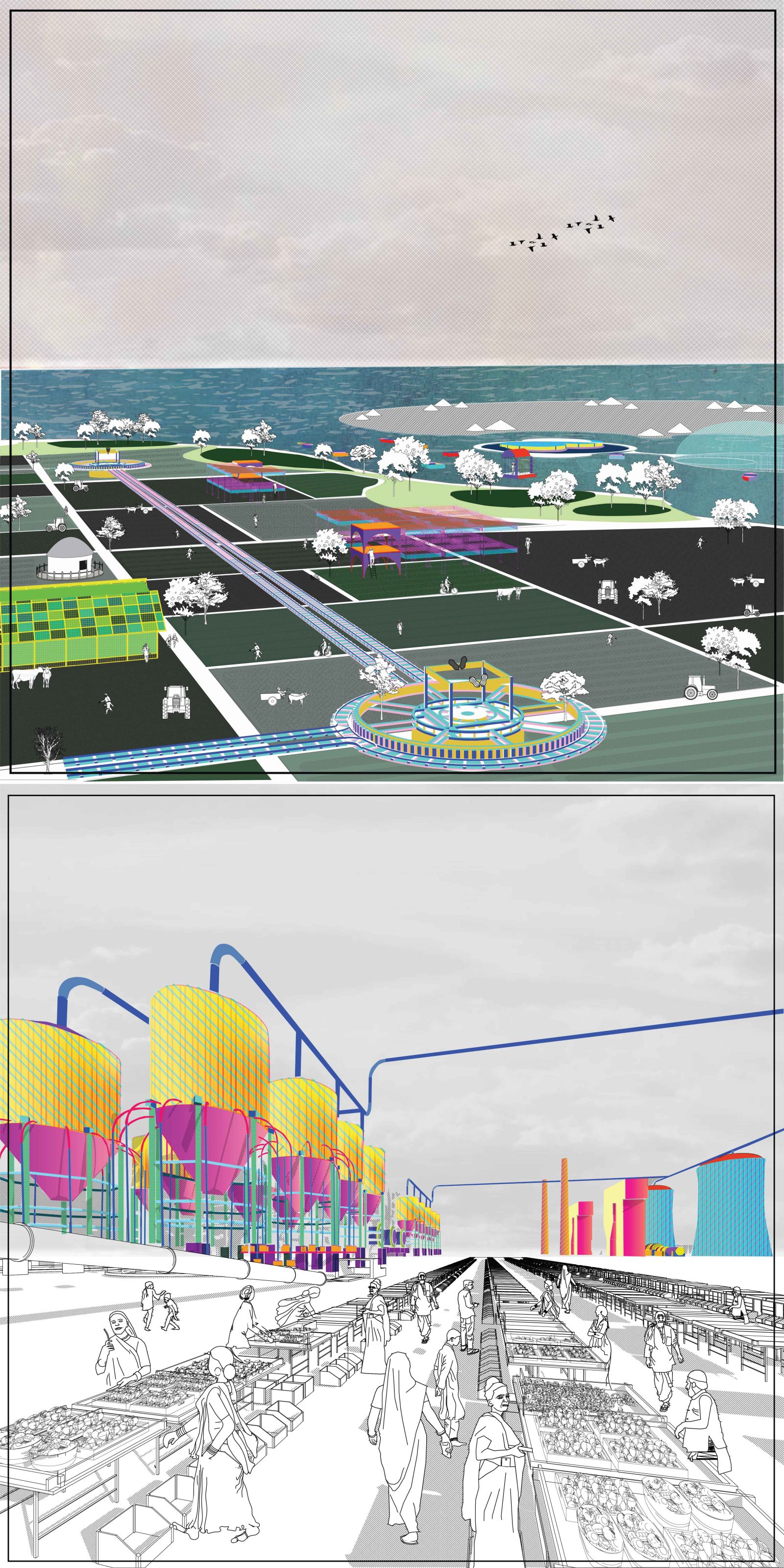
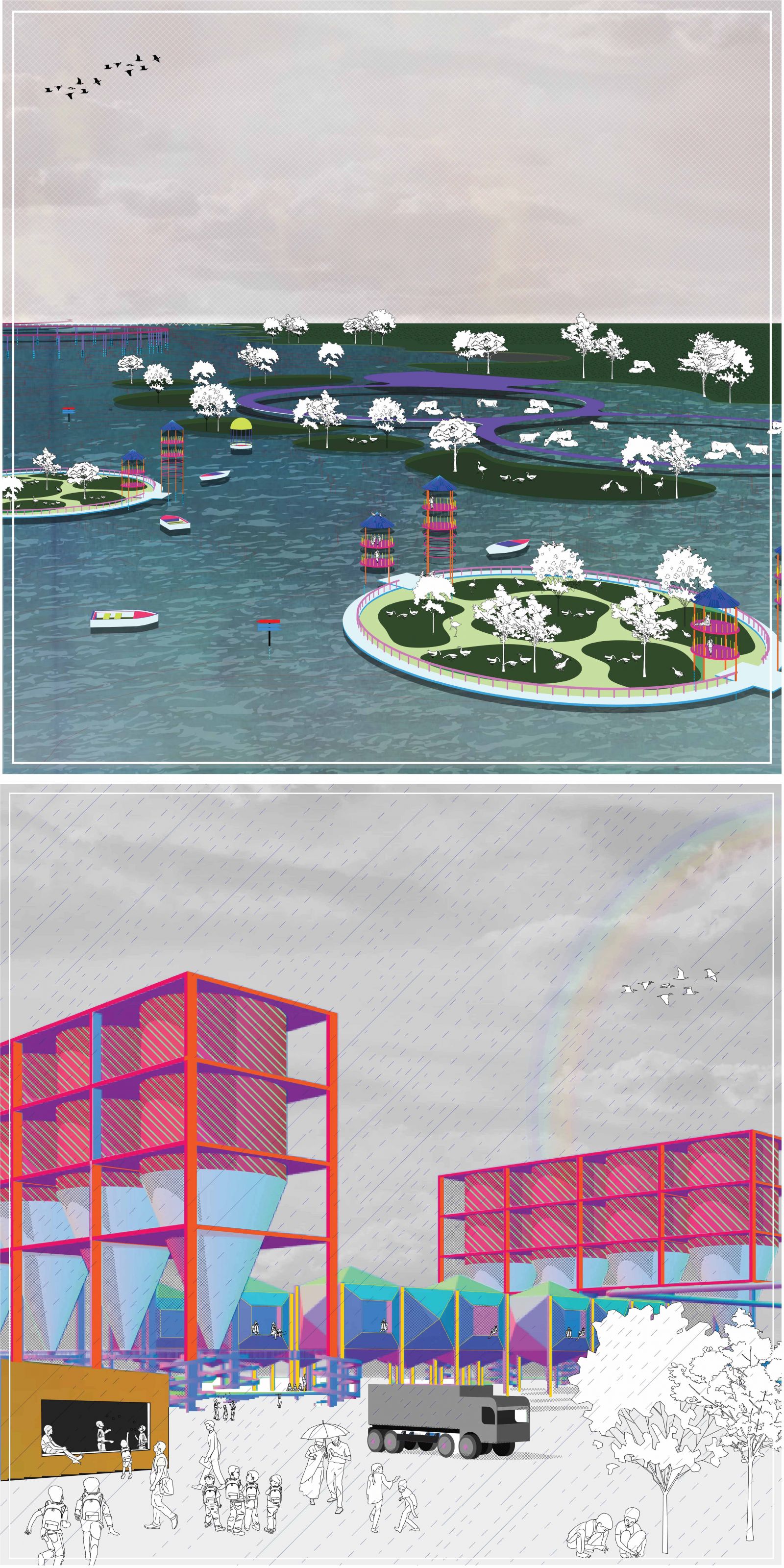
An Oasis of Hope: An attempt at redirecting the attention to places like Lakhpat where the residents don't have to surrender their lifestyle and livelihoods to water scarcity. This project also aims to highlight the potential of a water body to be able to create a resilient system by co-depending on other subsystems that can flourish in the presence of water.
City Scale-
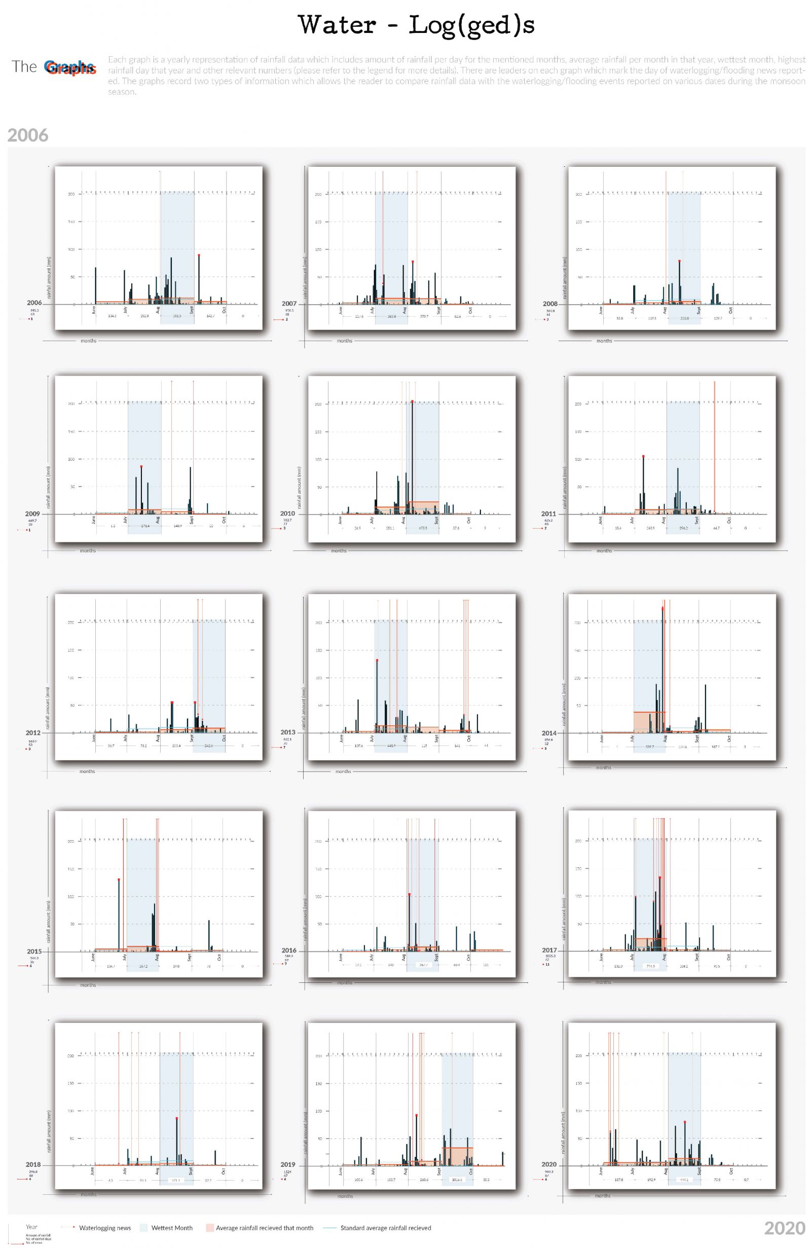
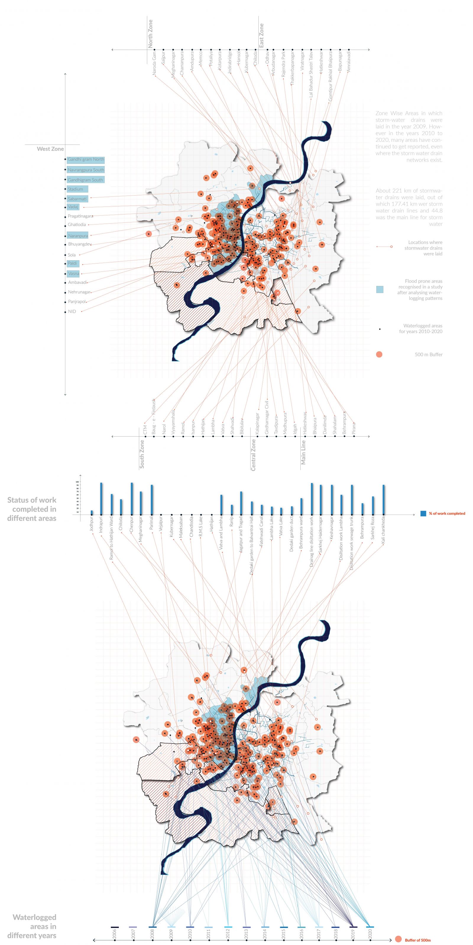
Water Log(ged)s: The project investigates rainfall patterns and waterlogging for Ahmedabad city by recording per day rainfall data over the years, news reports and spatial layouts of relevant infrastructures.

View Additional Work

Report Content

The map Wetness Dissected is a sectional plan representing rainfall graphs in different districts of Gujarat overlaid across their respective plans. Gujarat’s rainfall is a wide range that goes from 400 to 2000 mm on an average in its different districts. The infrastructure built to adapt to this range, are dams and reservoirs, Narmada project being the most significant one. The region of Kutch which is also the largest district of Gujarat falls under the lowest rainfall amount received. This makes Kutch the most vulnerable district of Gujarat in terms of reliance on its natural resource of water. Its vulnerability makes it rely on supply pipelines and groundwater. This mapping investigated further into Kutch’s rainfall patterns to understand its climate and bring forward the uncertainty of it. Kutch’s rainfall average is 400mm, an average that is the result of irregular and at times disproportionate rainfall amount received yearly.

From the subdivisions of Kutch, the subdivision Lakhpat stands with the lowest rainfall amount received in this district, which is only 350 mm of average rainfall per year. Furthermore where local villages complain of extreme water scarcity, in the same subdivision the industries continue to get water. There have been reports that claim how local occupations have declined because of water scarcity and pollution from these industries. The wildlife sanctuary in Lakhpat has also seen reduction in its protected area for allowing these industries to thrive around it. The speculation is situated in Lakhpat's limestone rich zone Malda, a site where there is a cement industry and limestone quarry proposed within very proximal distance from remote villages where there is no certain water supply and also absence of basic infrastructure.

The proposed set of infrastructure by the industry includes thermal power plant, cement plant, waste water treatment plant and a desalination plant.

The industry also proposes to fulfill the 1500 cu. m water need/day during the course of production through by treating water drawn from Kori Creek and treated in the proposed desalination plant. It also proposes to fulfill its water needs by using the available groundwater which will further worsen the already fragile water scarce condition of Lakhpat. The speculation "An Oasis of Hope" is a scenario placed in a timeline where after years of excavation, digging, drilling and extracting, the limestone mining industry has exited and left behind a huge void of 23 lakhs sq. m alongside the desalination plant and the rest of the infrastructure that facilitated the whole process in the dry land of Malda in Lakhpat.

The speculation imagines this post-industry site to be a potential for situating a bio-diverse water conserving eco-parcel that is run by and for the people of Lakhpat. The project is a point of relief, refuge and pleasant contrast that values and protects the declining occupations while also improving the neighborhood and ecological health overtime.

The template of the Oasis is categorised into three parts: Relief, Refuge and Contrast. The three categories are a translation of the typical character an Oasis reflects in its original definition. The elements of refuge are the occupational supporters, the elements of relief are the recreational and ecology focused supporters, and the elements of contrast are the water sensitive supporters of the Oasis. The primary element of contrast is the water filled quarry.

With the abundant water availability, the elements of refuge that is, the grain and vegetable farmlands, greenhouses and horticulture rejuvenate the occupation of agriculture. The conveyor belts, now swap belts, are also elements of refuge, with the function of exchange and transit for the produce between the settlements and also as a vehicle for them to the farmer's market. The reimagined factory infrastructure condenses the energy of its functions into supporting the quarry islands and thus promoting a self-sufficient system that is also capable of providing for the far placed villages from Oasis. Here, the refuge systems spill in, to cultivate into economies and accessible refuge markets and dairies. There are active silos and passive silos, both with the function of water conserving and distribution. The active silos fill up water lorries everyday, whereas the passive silo conserve water for emergency situations.

As a get away from the climate of Kutch, this pulsing ecology creates a soothing microclimate. The elements of contrast- floating wetlands, shore wetlands and forest area add on to the ecosystem supporting Narayan Sarovar Sanctuary nearby and serve as habitats for flora, fauna and avifauna. The elements of relief- bird's watch, cattle pools, human pools and escape pavilions act as vantage and engagement points for letting the residents enjoy. Malda, the most proximal village which had only a 2% literacy rate, now participates in learning at the proposed school, a refuge element reimagined in the warehouse of the factory. The water buses leave with water and come back with people ready to access this Oasis of Hope.

These graphs collate widely two things: per day rainfall data for years 2006 to 2020 and waterlogging/flooding news reported on different dates for the respective time period as well. These graphs are a method of comparing and analyzing the situations that led to waterlogging or flooding by coinciding layers of rainfall data alongside the dates of news reports. It is noted that many times even on days where there was rainfall less than the average amount of rainfall, waterlogging was reported.

The map 2009 SWD marks all the areas of Ahmedabad's zones in which the storm water drains were laid. The placement of storm water drains and waterlogged areas in the years following 2009 are compared here. The map Where + When is layered with different locations reported to be waterlogged over the years 2006 to 2020 alongside the status of work (on laying of storm water drains, desiltation of storm-water drains, lake development projects, laying of drainage networks etcetera) completed in various spots as specified in the Ahmedabad Municipal Corporation website. The locations represent the minimum number of waterlogged/flooded locations as per the mentions in the news articles. It is noted that many areas that have been included in the stormwater drain network, are also reported to be waterlogged repeatedly.