Shrayana Ray

UR2008

Watta Gully !

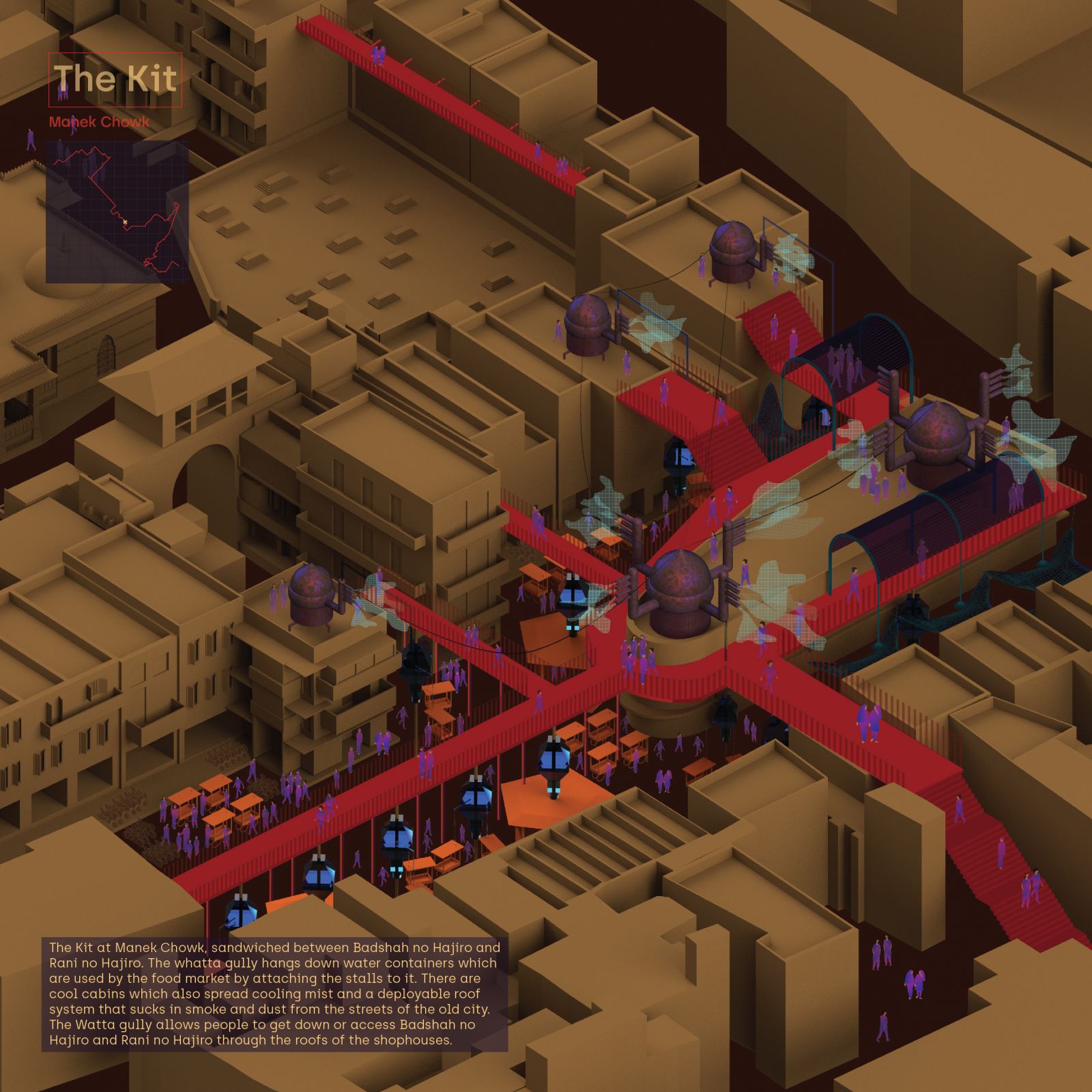
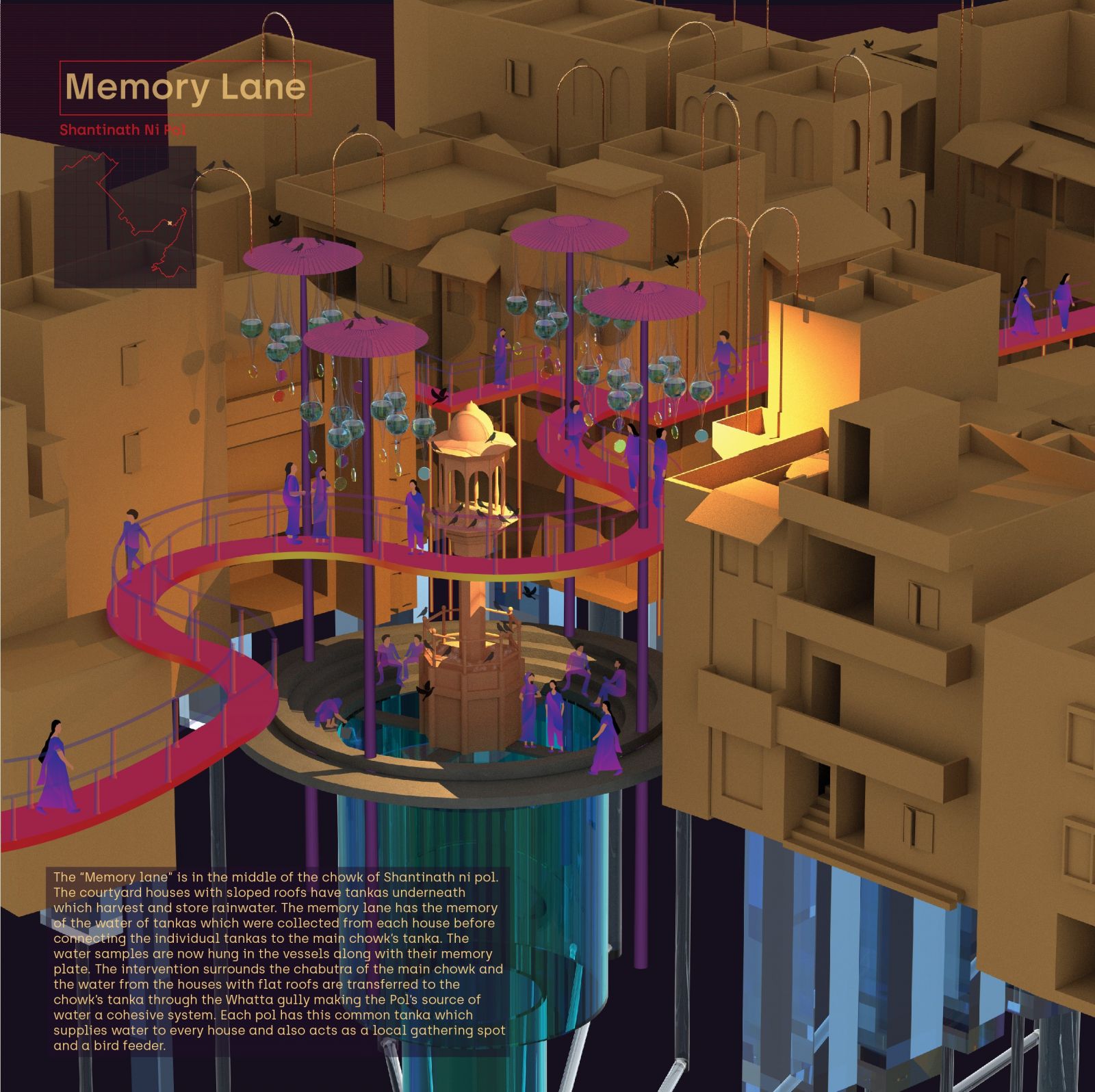
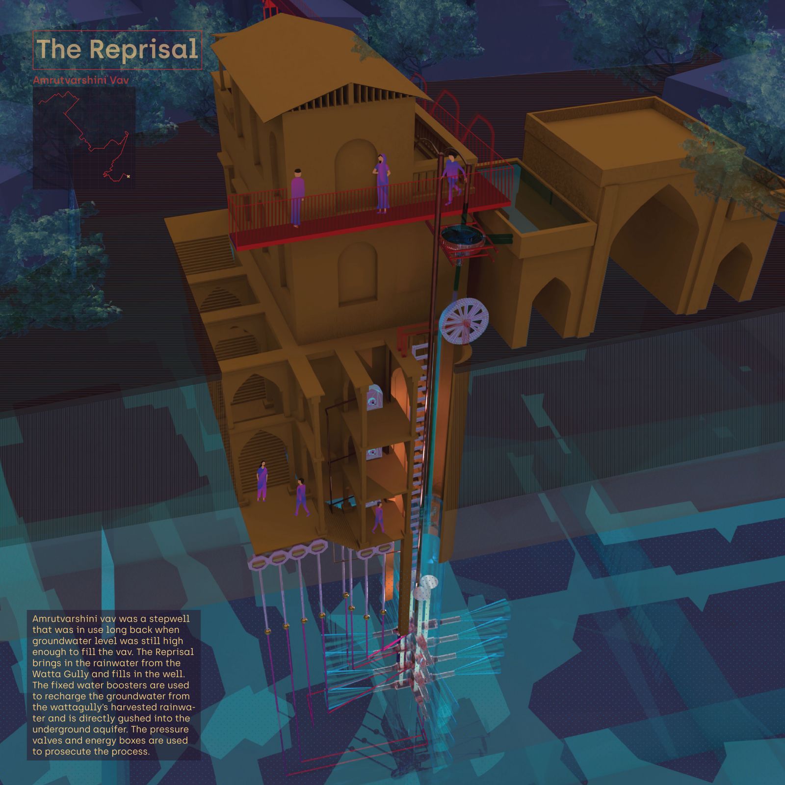
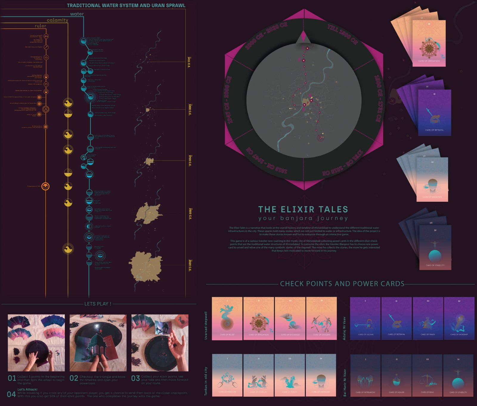
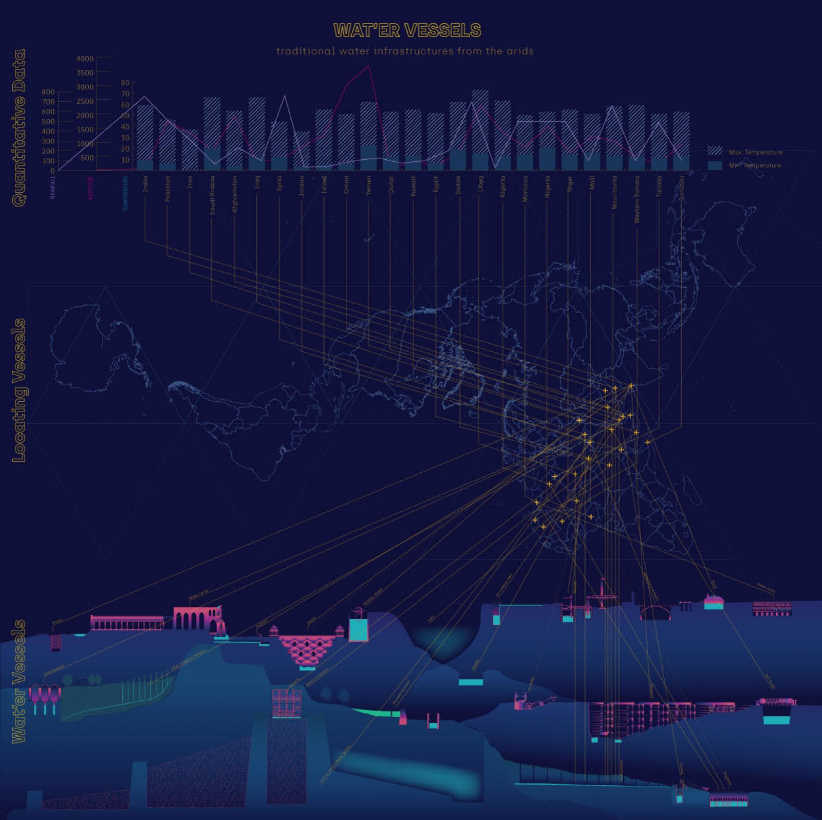
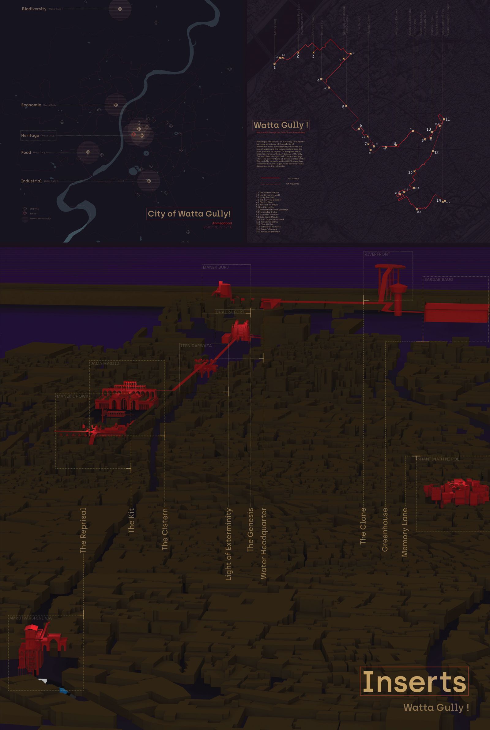
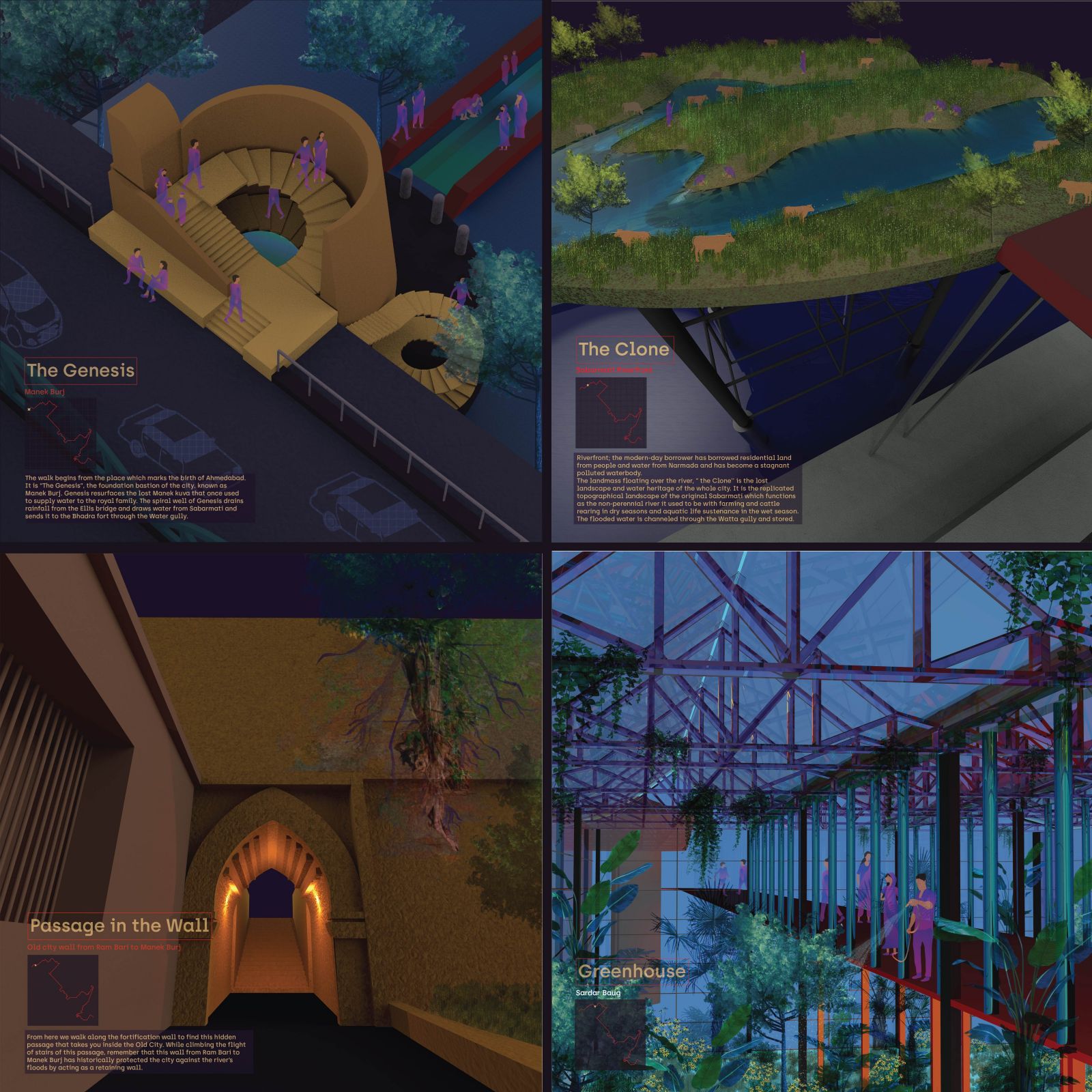
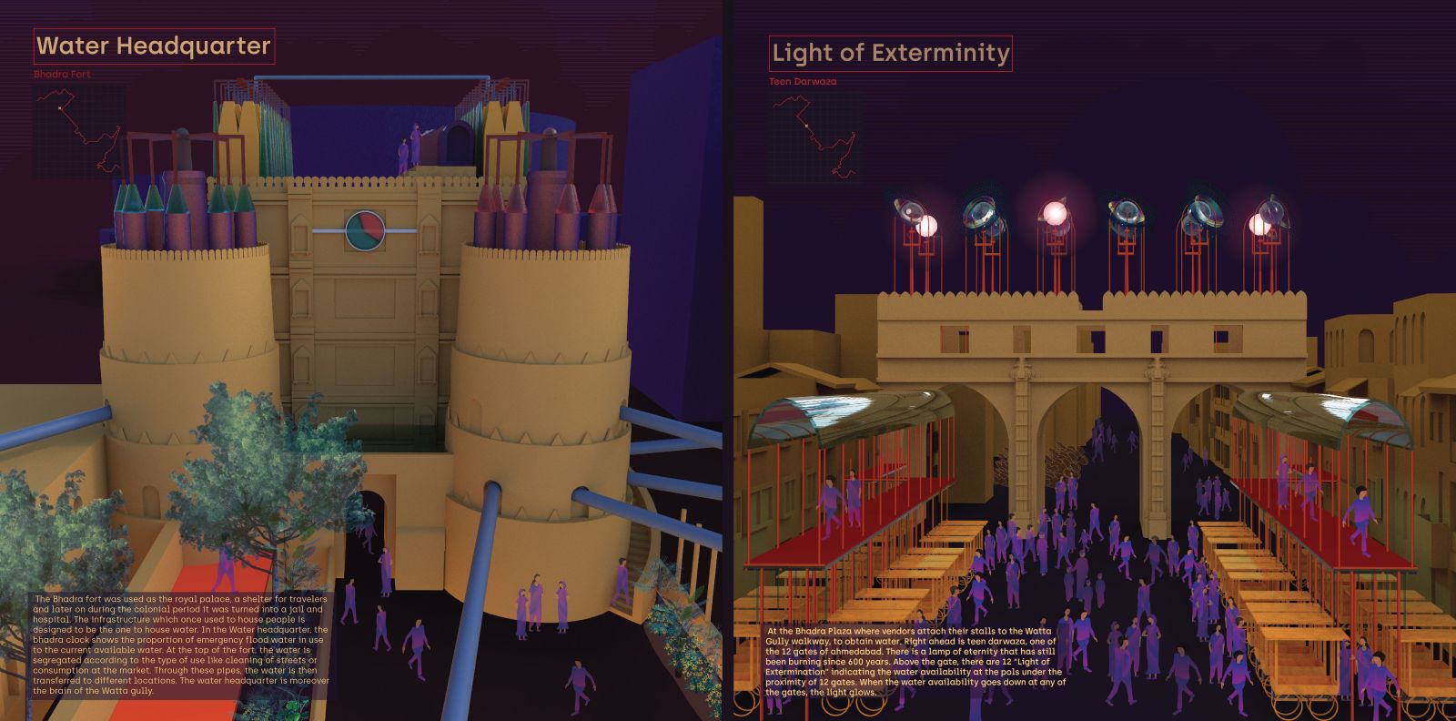
Water is tied to the customs and traditions of life. The traditional water systems that are informed by geography and shaped by culture not only narrate stories of life around water but are also positioned to reflect our relationship with water today. From arid to semi-arid regions of the subcontinent, stepwells and tankas are two such traditional water harvesting systems found in the city of Ahmedabad. Whatta Gully is positioned at the center of these historical systems. It is a critic at our existing relationship with water and the banality of our contemporary water infrastructure systems. 

View Additional Work

Report Content

Urbanisation has a great effect on the run off pattern by contributing to the existence of building surfaces. These surfaces already inhibit layers of pollutants that have blanketed upon each other over a period of time. The first flush of stormwater runoff washes away the pollutants on the citified base and further gets accumulated which is the pollution which has either suspended solids or dissolved ones. The moment the rainwater falls on it, it's not “just” water anymore. There are a lot of things that the water interacts with and takes them with itself as it flows. This website zooms into these unnoticed tiny day to day pollutants and our contribution to its existence. The speculation watered down which means “to simplify”, aims to remove all the pollutants that are taken away with the rainwater runoff. Overall, Watered down is an interactive visible space to separate rainwater runoff from the pollutants.

The timeline is divided in three categories namely ruler, water and calamities. All these three have been looked at in respect to the urban sprawl and the different water infrastructure which came up along time. While doing this the traditional water infrastructure of Ahmedabad has been looked in detail . The Elixir Tales is a narrative that looks at the overall history and timeline of Ahmedabad to understand the different traditional water infrastructures in the city. These spaces hold many stories which are not just limited to water or infrastructure. The idea of the project is to make these stories known and fun to everyone through an interactive game.

The mapping starts with looking at the Arid countries which have similar climatic features as Gujarat. To compare the water infrastructures, the rainfall and altitude of each place has been taken into consideration. The water infrastructures that we call "water vessels" contain the water and each has its own unique function.

Whatta Gully is positioned at the center of these historical systems. It is a critic at our existing relationship with water and the banality of our contemporary water infrastructure systems. The watta gullys of different kinds are spread at 5 different parts of Ahmedabad city. The speculation zooms into the one which is carefully situated along the heritage walk which will link the traditional water infrastructure systems of the old city. With speculative projects inserted along critical pause points of the walk, the design creates memories and futures of water linking old systems with new. It creates a network of sustenance that enables and imagines a new way of living with water for the heritage city of Ahmedabad. Watta gully is moreover a walking route starting from the Manek burj and ending at the Amrutvarshini Vav.

Genesis resurfaces the lost Manek kuva that once used to supply water to the royal family. The spiral well of Genesis drains rainfall from the Ellis bridge and draws water from Sabarmati and sends it to the Bhadra fort through the Water gully From here we walk along the fortification wall to find this hidden passage that takes you inside the Old City. While climbing the flight of stairs of this passage, remember that this wall from Ram Bari to Manek Burj has historically protected the city against the river’s floods by acting as a retaining wall. The landmass floating over the river, “ the Clone'' is the lost landscape and water heritage of the whole city. It is the replicated topographical landscape of the original Sabarmati which functions as the non-perennial river it used to be with farming and cattle rearing in dry seasons and aquatic life sustenance in the wet season. The next stop is the Sardar Baug water tank which now delivers water during emergency situations and “t

In the Water headquarter, the bhadra clock shows the proportion of emergency flood water in use to the current available water. At the top of the fort, the water is segregated according to the type of use like cleaning of streets or consumption at the market. Through these pipes, the water is then transferred to different locations. The water headquarter is moreover the brain of the Watta gully. Light of Extermination” indicating the water availability at the pols under the proximity of 12 gates. When the water availability goes down at any of the gates, the light glows.

Next, the Watta gully lands you at the Jama masjid from the behind through the “water cistern” which has the largest tanka of the old city. This water cistern allows women to access the mosque without any restriction and the pilgrims could rest and take shelter. The water at the cistern is transferred to all the religious places of the old city.

The fourth pause is the Manek Chowk, sandwiched between Badshah no Hajiro and Rani no Hajiro. The whatta gully hangs down water containers which are used by the food market by attaching the stalls to it. There are cool cabins which also spread cooling mist and a deployable roof system that sucks in smoke and dust from the streets of the old city. The Watta gully allows people to get down or access Badshah no Hajiro and Rani no Hajiro through the roofs of the shophouses.

The memory lane has the memory of the water of tankas which were collected from each house before connecting the individual tankas to the main chowk’s tanka. The water samples are now hung in the vessels along with their memory plate. The intervention surrounds the chabutra of the main chowk and the water from the houses with flat roofs are transferred to the chowk’s tanka through the Whatta gully making the Pol’s source of water a cohesive system.

Amrutvarshini vav was a stepwell that was in use long back when groundwater level was still high enough to fill the vav. The Reprisal brings in the rainwater from the Watta Gully and fills in the well. The fixed water boosters are used to recharge the groundwater from the wattagully’s harvested rainwater and is directly gushed into the underground aquifer. The pressure valves and energy boxes are used to prosecute the process.

Project Video