• Home
  • FA
  • LA4010
  • 'Paripath' 10.0 Igniting a network of community

Anushree Mohan Baxi

LA4010

'Paripath' 10.0 Igniting a network of community

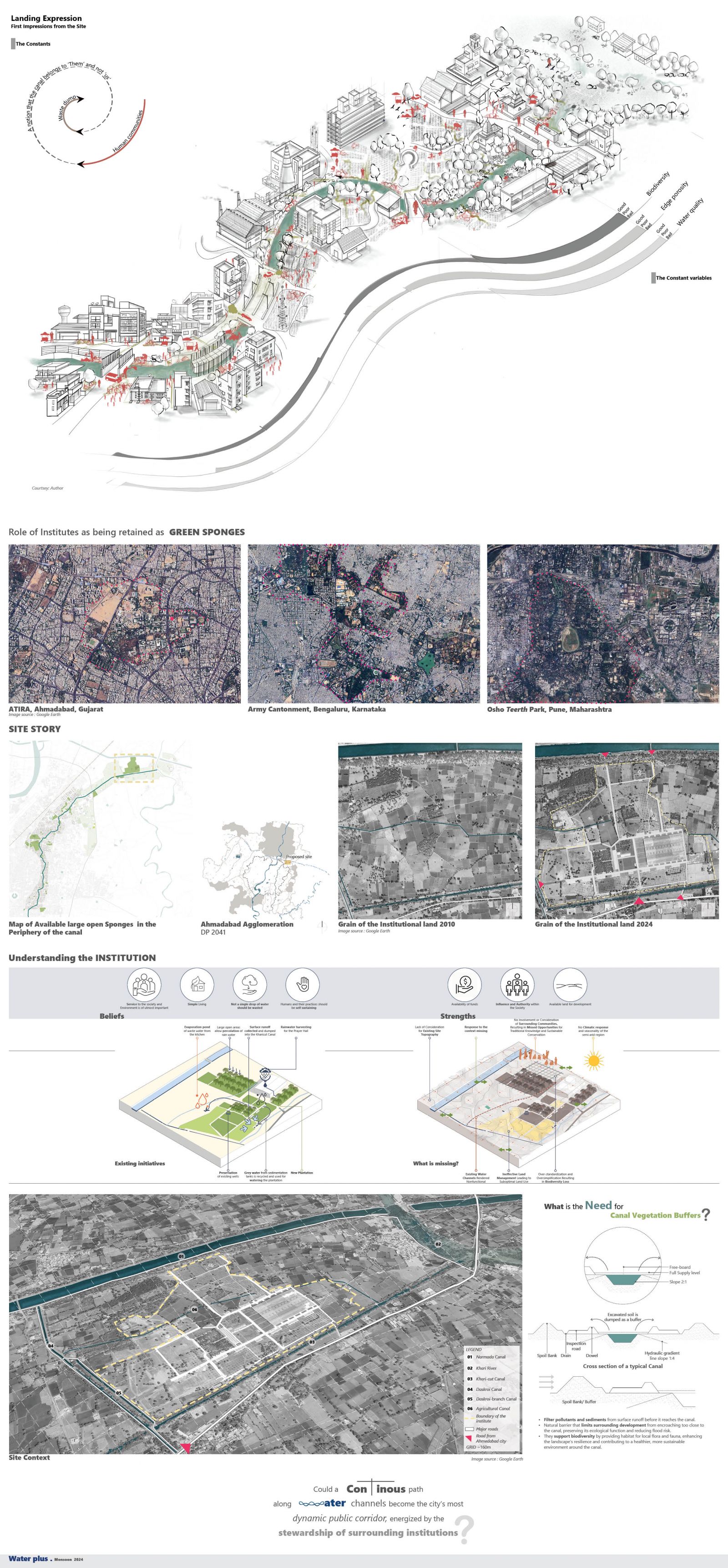
As our cities expand, urban green spaces—often referred to as the “lungs” of the city—are increasingly vanishing. However, a few resilient green areas remain, many of which belong to large institutional or government campuses. On the northeastern edge of Ahmedabad, a notable 400-acre plot owned by an international spiritual organization serves as one such vital green sponge. When viewed from above, this land is framed by three water channels, with the Khari River bordering its far edge. This project envisions transforming these interconnected water edges into a dynamic public corridor, addressing the needs of the city’s growing population while supporting local ecology and establishing corridors for biodiversity. With the institute at its core, this initiative fosters an enduring connection to the surrounding waterway public spaces, ensuring their preservation amid the rapid development anticipated from the proposed Ahmedabad-Gandhinagar metropolitan expansion. This vision not only serves the community but also safeguards a green sanctuary in the face of impending urbanization. 

View Additional Work
Report Content

As the canal transitions from rural villages to dense urban centers, its character changes dramatically—biodiversity diminishes, edge porosity hardens, and water quality deteriorates. Land use shifts from natural landscapes to industrial and commercial zones, while human presence remains constant, accompanied by neglect and waste dumping. Large institutions along the canal, like ATIRA and spiritual campuses, act as urban green sponges, balancing ecological preservation with urban functionality. These green spaces mitigate urban heat, manage stormwater, enhance biodiversity, and foster community engagement. A 400-acre institutional site near the canal’s origin holds immense potential to become a resilient green lung, crucial in the rapidly developing Ahmedabad-Gandhinagar corridor. Positioned near major water channels, it can exemplify water-positive design and ecological balance. A connected pathway along these water channels could redefine urban public spaces, promoting stewardship by

The site’s drainage pattern flows from northeast to southwest, using its higher elevation to channel water into adjacent areas. Within the institutional boundary, this natural flow is enhanced by a network of stream corridors. The site features a prominent high point and two lower points , with water flowing from the Narmada canal's buffer slope into surrounding areas. Enclosed by multiple water channels, the site’s hydrological system is intricate and dynamic. A detailed matrix analyzes this water network, examining critical factors such as channel sizes, bed and edge characteristics, buffer zones, and land uses. This structured approach offers a comprehensive understanding of the site’s hydrological complexities and highlights its potential for integrated water management and sustainable design.

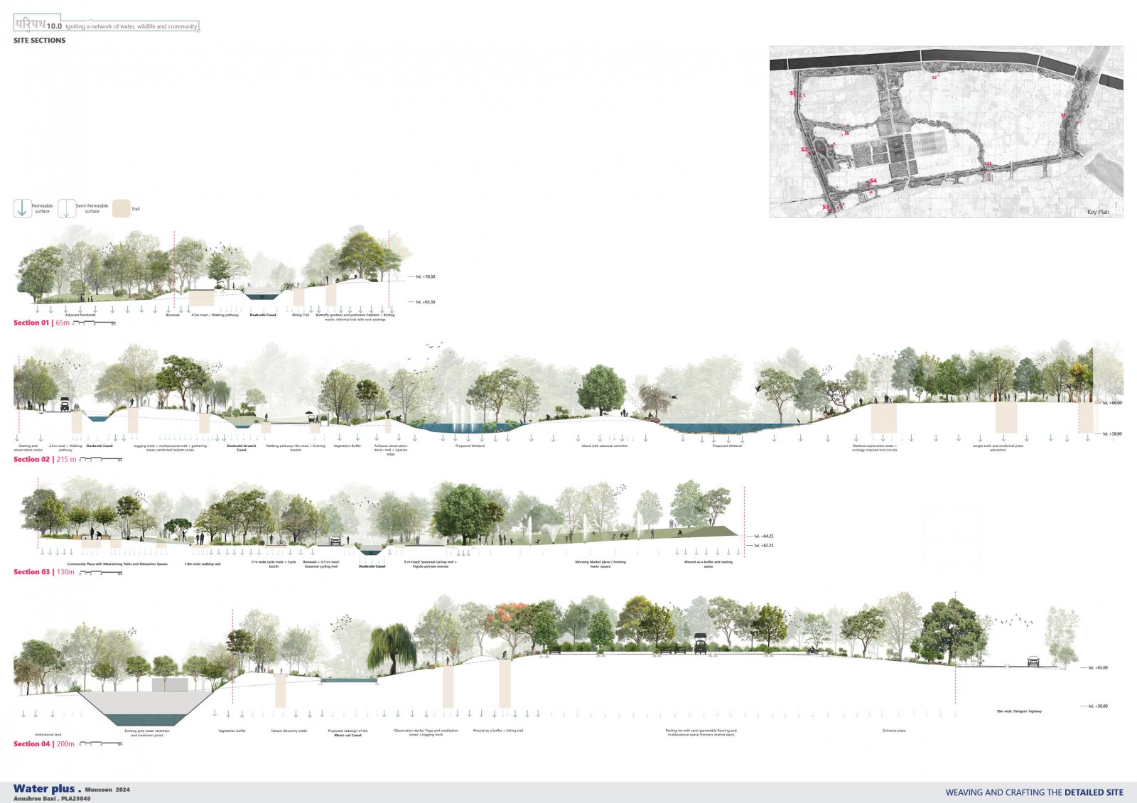
The project’s phased implementation addresses its complexity by clarifying processes that support specific programs, which generate public amenities as secondary benefits. This approach helps stakeholders identify their unique advantages while grounding these benefits in ecological principles. Programs are customized to each canal buffer, offering diverse, year-round user experiences day and night. Site sections reveal relatively flat land with gentle undulations and emphasize the varying dynamics of buffer zones. The institutional ‘Sacred Grove’ serves as a vital ecological corridor, linking these buffers and enhancing connectivity across the site.

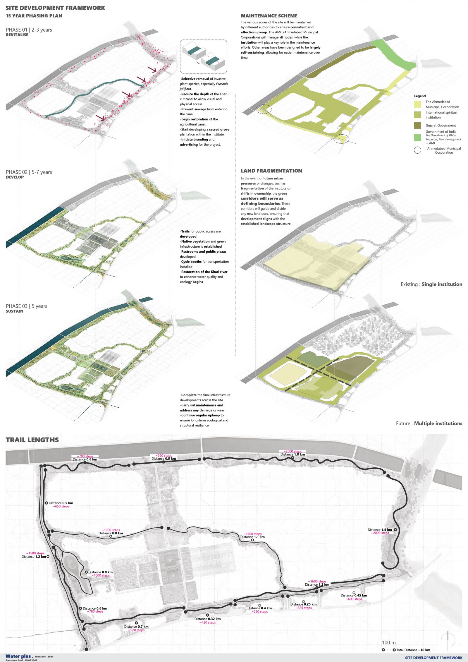
The site’s development will span 15-20 years, accommodating a variety of stakeholders. Vegetation buffers are designed as natural land-use dividers, ensuring continuity in case of ownership changes or site fragmentation. Trails are strategically placed at 300-400 meter intervals to break monotony and create seamless transitions between maintenance zones. Diverse trail lengths cater to individual preferences, enabling users to set goals and progressively explore larger circuits. Each trail segment offers a distinct experience, preventing repetition and fostering engagement. This dynamic design weaves a narrative for the community, where completing different circuits of Paripath 10.0 becomes a shared story, enriching the site’s identity and creating deeper connections among its users.

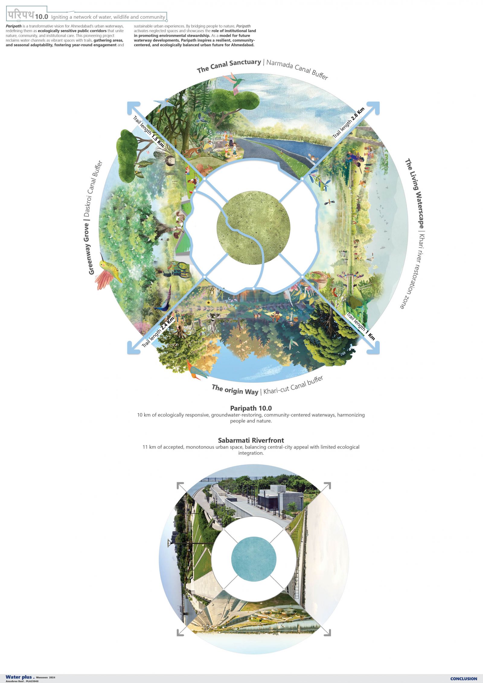
At the canal's origin near the Narmada Canal, the design emphasizes preserving its natural character with wide buffers, meadows, bird habitats, bird walks, and informal rock seating. As the canal approaches its confluence with the Khari-cut canal, the design transitions into more formalized spaces to foster public engagement through structured activities. A prominent entry to Paripath 10.0 features multipurpose seating, a small amphitheater, cycling booths, and a water square for seasonal markets, with seating mounds providing a scenic view. Section 04 serves as the trailhead, offering parking, multiple trail options, and a shallower canal to enhance usability and accessibility for visitors.

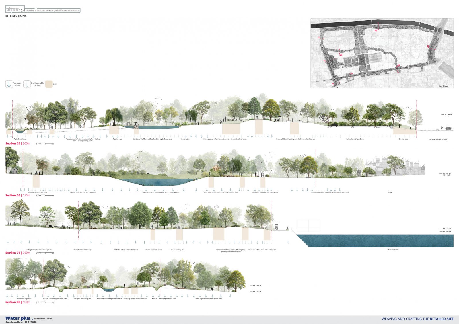
At the junction of the Khari-cut and Agricultural canals, a widened basin features trails, picnic areas, markets, mound seating, and parking, with select trails extending over the water for a unique experience. The Khari River restoration zone incorporates designed ponds for water retention, removal of invasive vegetation, and seasonal interpretive trails to enrich visitor engagement. In the Narmada Canal buffer, a moat separates farmlands from undisturbed fauna zones, while winding trails weave through dense vegetation alongside a continuous channel-side pathway. Mounds provide seating and gathering spots for relaxation. The Agricultural Canal buffer, characterized by its narrower design, includes moats and mounds to encourage brief walks and resting opportunities. This zone remains accessible only during morning and evening hours, fostering a tranquil and controlled interaction with the landscape.

The Khari-cut Canal transforms into a space for nature enthusiasts, community events, and shaded gatherings during the dry pre-monsoon season. The Khari River’s dry bed supports seasonal farming and educational activities, while restoration enhances biodiversity year-round. The Agricultural Canal, with year-round water flow, supports seasonal fauna, ecological diversity, and community engagement.

The design aims to revitalize the water channel into a dynamic public corridor. Preserving green sponges could enable the site to recharge up to 25,300 cu.m./year of water. However, increased concretization could reduce recharge potential by 80%, leading to higher runoff and increased flood risks in surrounding areas.

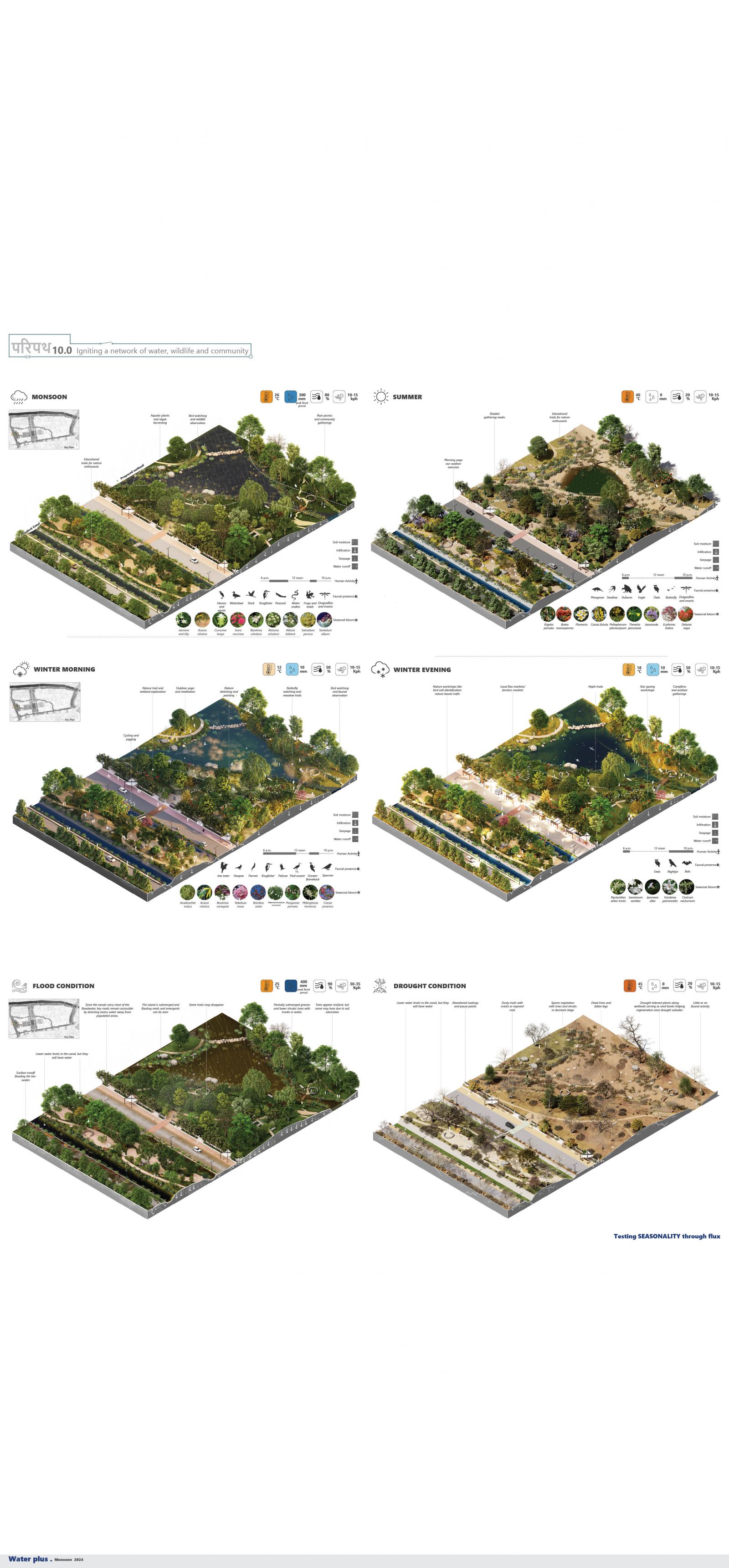
The site's resilience is tested under diverse seasonal and extreme conditions: Monsoon: Avifauna and animal activity flourish; trails may vanish; canals and wetlands rise; blooming Acacia trees enhance the environment. Summer: Shaded paths attract visitors; blooming Amaltas and Delonix trees add vibrancy; wetlands retain sparse water for fauna, maintaining microclimatic balance. Winter: Morning fog graces waterbodies; vibrant evening markets activate the Greenway Grove; meadows and blooming trees enhance scenic beauty. Floods: Canals overflow; bioswales manage water; wetlands flood, reducing island access; raised groves stay unaffected. Drought: Cracked soil and dried vegetation dominate; Narmada Canal mitigates severe water shortage; fauna activity declines.

Paripath reimagines Ahmedabad’s urban waterways as ecologically sensitive public corridors, blending nature, community, and institutional care. This project revitalizes water channels with trails, gathering spaces, and seasonal adaptability, fostering year-round engagement. By connecting people to nature, Paripath promotes environmental stewardship and sets a model for resilient, community-centered urban development.