Anjali Katare

4500-2

Planning I - Ward of Paldi

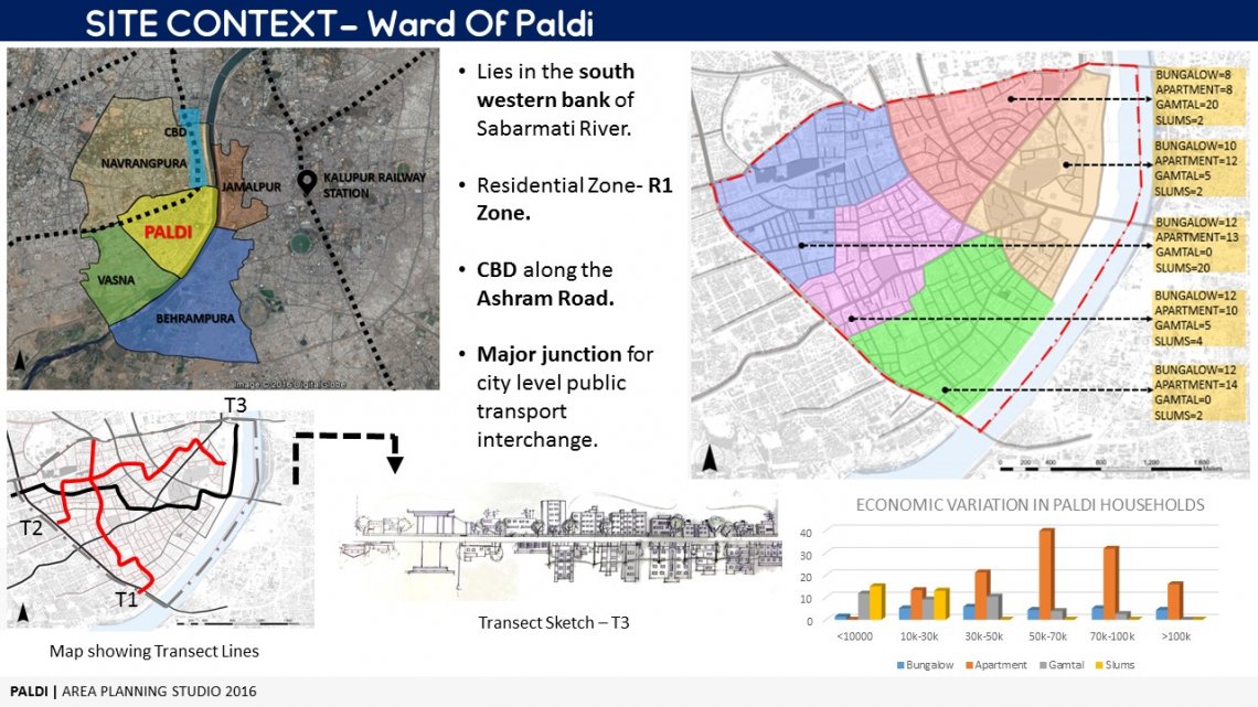
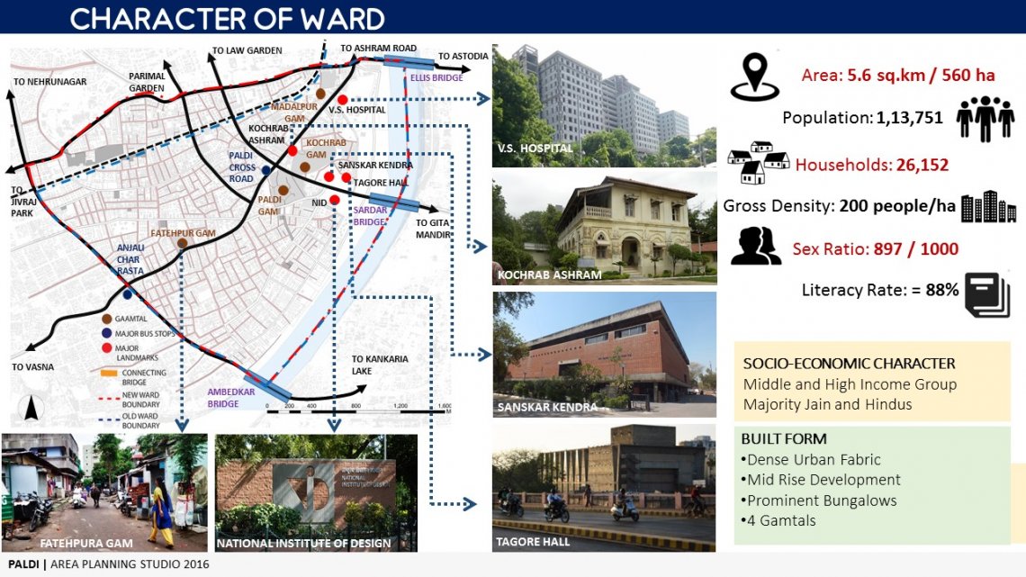
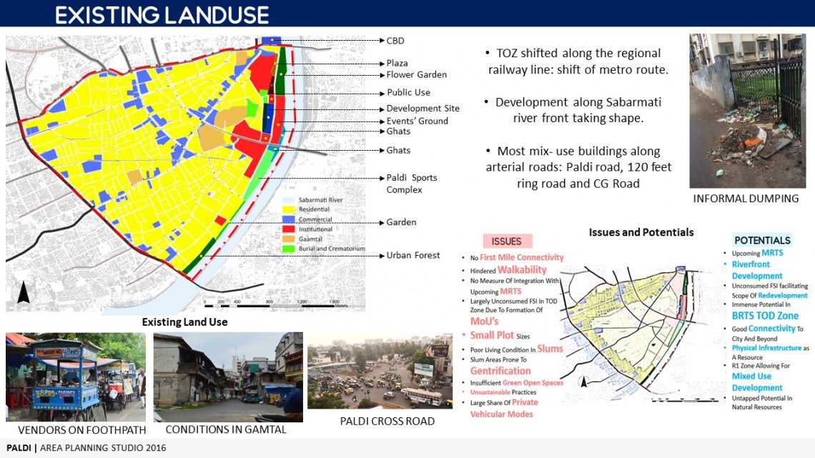
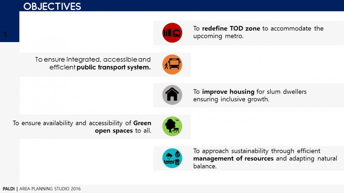
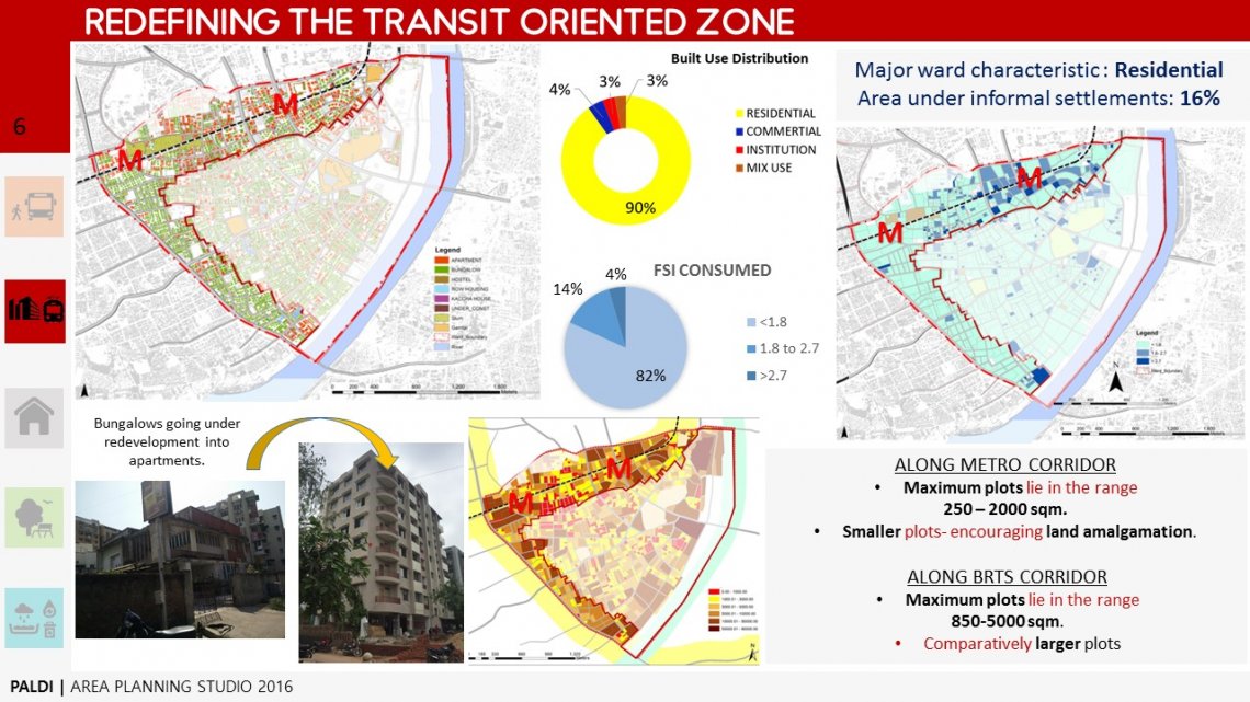
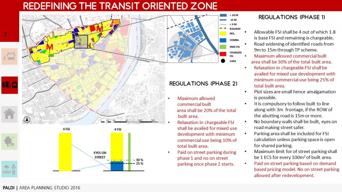
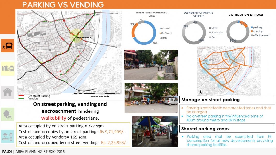
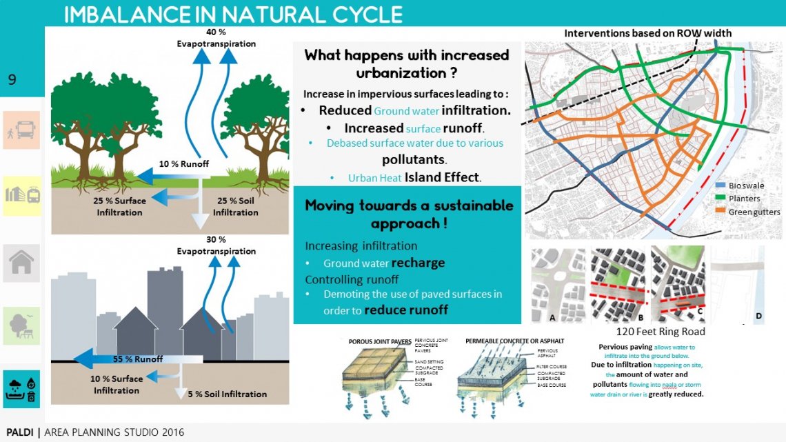
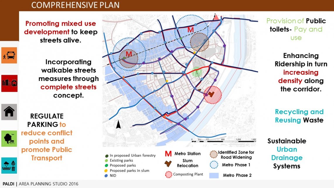
The first semester - Area Planning Studio for MURP I required us to study the ward of Paldi. It sought to make students aware about the planning process and explore how an area could be envisioned to be developed for the next 10 year span.


Report Content

A ward is a smallest administrative unit of a city. Planners’ task is to develop and plan a city that responds better to both the residents and environment. For such a responsive city, one not only needs to improve the whole, but to involve and enhance the parts as required too. Certain measures might be effective when carried out as centralized systems city-wide, while certain might be area specific issues that are needed to be resolved. This attempts to resolve such area specific issues in the

Introduction to the Ward of PaldiPaldi is an affluent area located in South Western Ahmedabad, India. It accommodates Sanskar Kendra museum by the renowned architect Le Corbusier as well as Tagore Memorial Hall. The National Institute of Design is first of the many institutes set up in Paldi. It also housed one of the very first cooperative societies that came up in Ahmedabad. The communities that live in Paldi are mostly either Jains, Hindus or Muslims with minority of several local communi

The ward of Paldi lies in the West Zone. It is primarily a residential posh area. Corporate offices and city centres of many national and international companies like ICICI Bank, Royal Bank of Scotland, Gujarat Gas etc. are located within Paldi. There are few renowned institutions like Sanskar Kendra Museum, Tagore Memorial Hall and National Institute of Design. The ward connects to the east side of the city through three bridges- namely- Ellis Bridge, Sardar Bridge and Ambedkar Bridge.

The ward is classified as R1 zone, which is primarily residential. Although, along the major roads such as- along the S.M. Road, along the Paldi Road and along the 120 feet ring road, commercial activities are seen. These commercials are either accommodated in a mixed-use building or are informal commercials. Very few purely commercial complexes are observed. There are several institutions of regional and national importance in and around the ward. The riverfront had been developed, by reclaimin

Hence, in coming 10 years, we envision Paldi to have a sustainable, equitable and accessible future. Certain objectives have been set to achieve the same. These objectives are specific and driven, to help maintain the goal to meet the vision.

The potential for redevelopment is large. Although, BRTS has been introduced about 8 years ago, and it can be seen that higher FSI provided in the TOZ has not been utilized even now. This behaviour is due to slow and stagnant market in real estate for past 5 years and partially because there exist housing societies in that locality, which have undergone a MoU, stating that there would be no development without all 100% of the members giving a consent and the development will not deter from prese

• The land use affects the feasibility for transport, since denser regions imply higher ridership and transport in turn facilitates development, denser fabric directly affects the ridership obtained by any Rapid Transit System, thus both these systems cannot be viewed in silo, and are deeply related. TOD aims to increase the density along the corridor hence facilitating the feasibility of Public Transport.• FSI along the TOD i.e. the unconsumed FSI along BRTS corridor materialized because of t

• The dominance of private vehicles over public transport in mode share inspite of such a good multi-modal transport network supported by efficient IPT which is causing parking issues.• No first-mile connectivity, although a very strong last mile connectivity is captured through surveys.• Motorized vehicles, encroachments, on street parking and vending activities are creating conflicting scenario with pedestrians, reducing walkability in the ward.• This also forces the pedestrians to walk

With rapid urbanization observed on land sites, a significant change has been noticed in the natural hydrological cycle. Before the development, the land used to have major portion of green cover and hardly any impervious surfaces. Such kind of proportions helped in easy and ample amount of water infiltration during rains. After going under the urbanization, the percentage of green cover and pervious surfaces reduced and impermeable surface area increased which ultimately hindered the water infi

The Comprehensive Plan combines and creates a single consolidated plan that reflects all the various interventions from separate sectors and spatially indicates how it will all work together. It also represents if there is any conflict of interests that needs to be solved.