Sandra Maria George

AR3596

UA6317

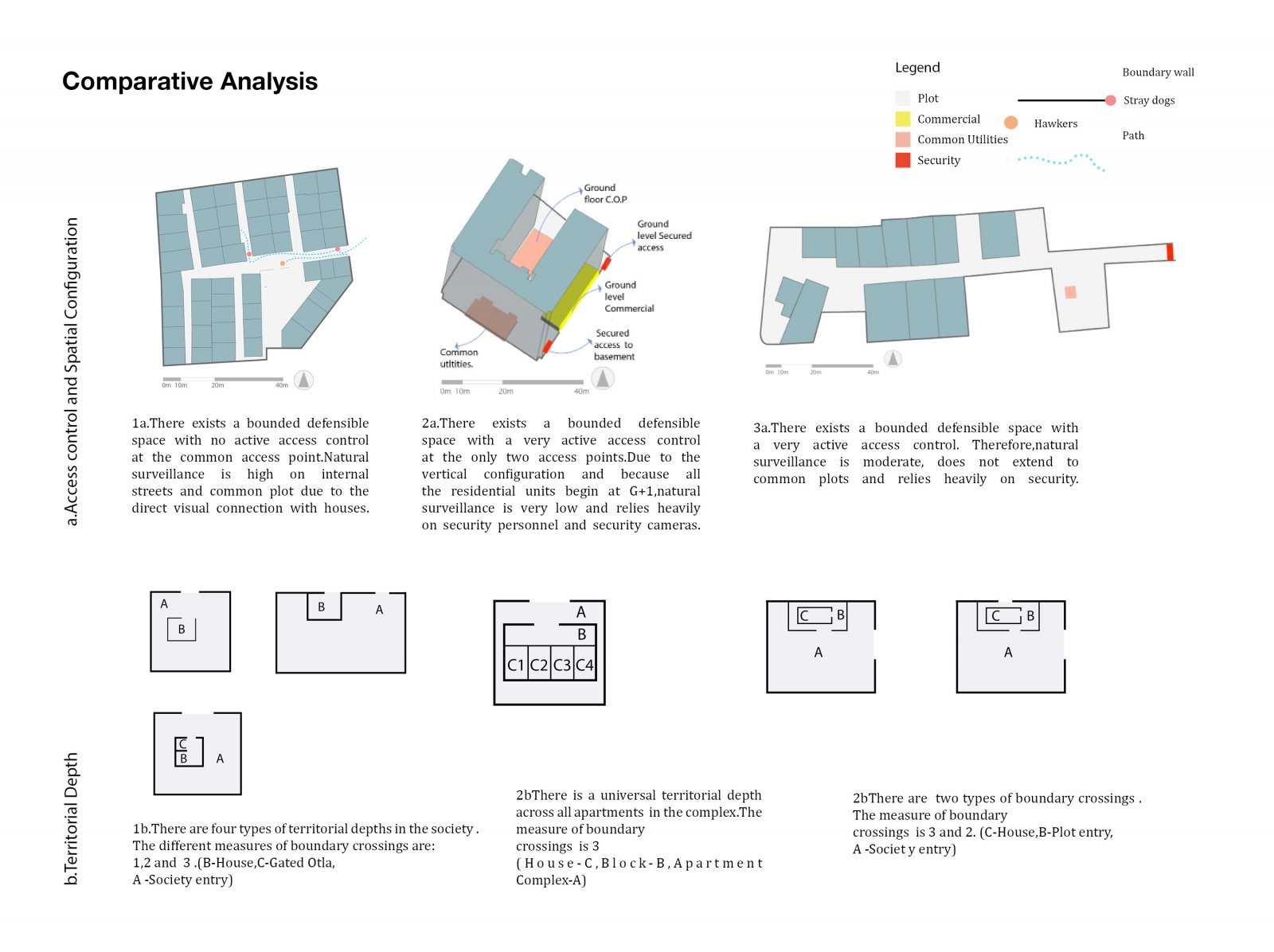
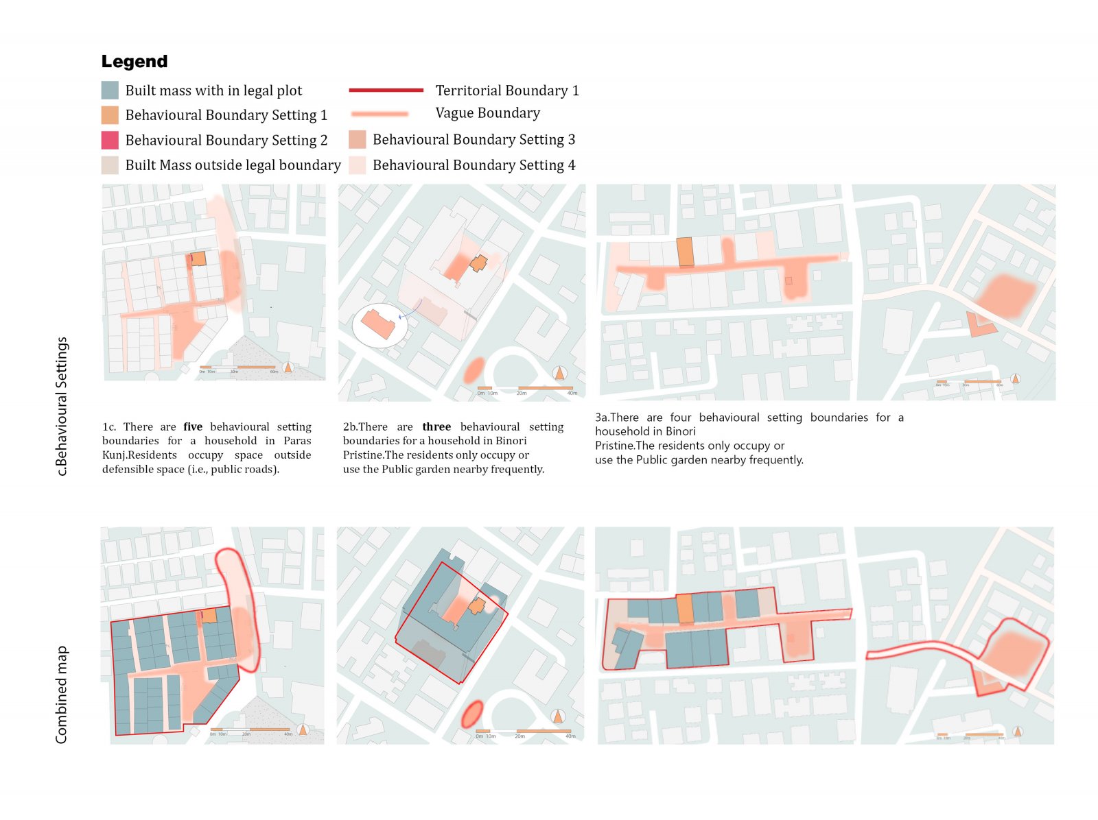
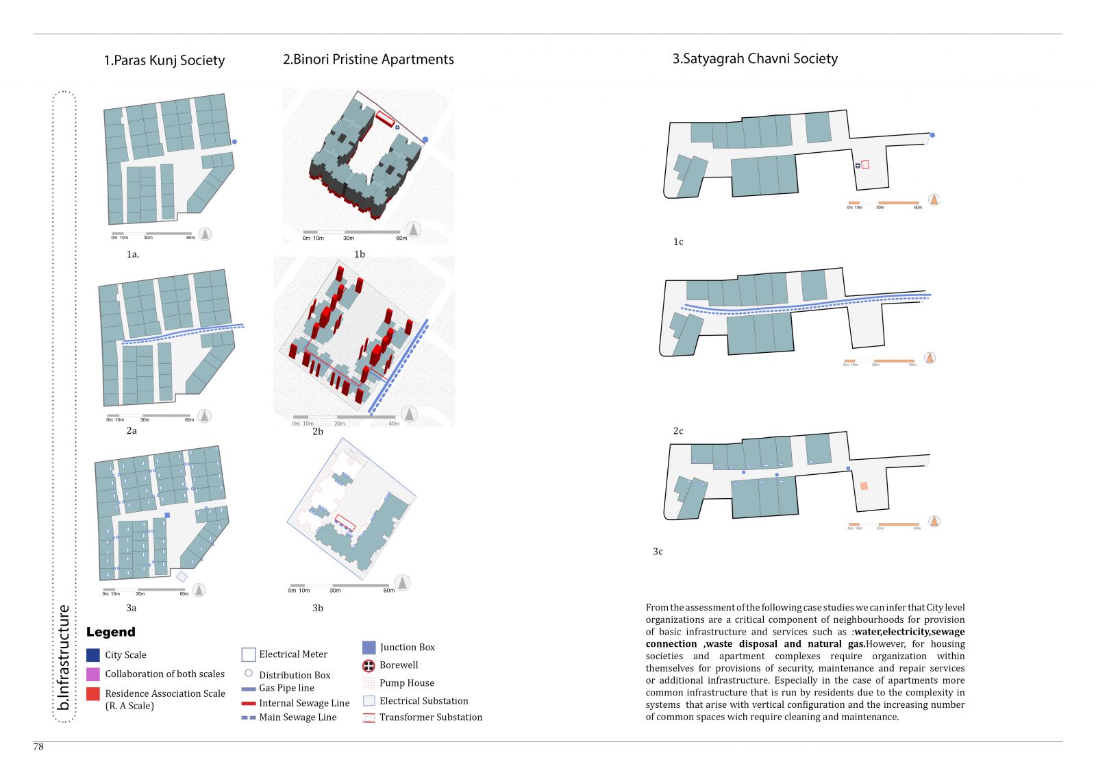
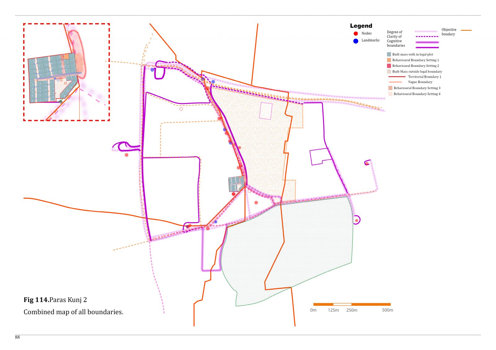
There is an increasing shift towards the utilization of neighbourhoods as sites of substantial intervention activity. Concerns about a manageable operation, specific implementation, control, and responsiveness of the target population have led to more neighbourhood collaborative models in planning. Since Clarence Perry defined the ‘neighborhood unit’ in the 1920s, we see a growing interest in defining a socio-spatial unit for cities. The general trends of current research acknowledge the overarching definition of the term neighbourhood by recognizing its spatial, social, and cognitive interpretations. The variety of interpretations of the term brings an understanding of the wider context in which the term is used. However, when conducting empirical research and deriving methods of neighbourhood delineation, the ambiguous nature of the concept becomes an obstacle. There are significant research gaps in deriving methods to determine and identify the neighbourhood and its boundaries or lack of it thereof. There is a bridge to be crossed from theory to practical application. This research aims to investigate the nature of neighbourhood boundaries. 


Report Content

In order to look at neighbourhood boundaries it is important to clarify the meaning of the neighbourhood as a concept and its relationship to the city. How do we define the term ‘neighbourhood’? Dictionary meanings associate the term with a place in vicinity, extent of a region resided by neighbours with a distinctive character or a part of the town or a city. (Merriam Webster, 2022) The spatial connotations of the word imply its usage in defining boundaries, building an identity and imparting a particular formal association. The usage of the term in relation to a larger whole say cities or towns or the people that inhabit the place highlights aspects of urban structure and organization. However, on taking a closer look there is no finality to the meaning instead it remains an elusive concept. This vague definition results from city planners, architects, and urban designers’ continuous engagement with neighbourhoods.

On the basic level of the concept, boundaries are assumed to separate what they distinguish. We often correlate boundaries to the edges of a container preventing leakage and separating entities. But with the complexity of the world we engage in, this simplification does not hold true. Boundaries also become sites of interaction through human activity and networks. For instance, conversation and interaction between two neighbours sharing a boundary becomes care-free and relaxed when there is a security and understanding of territorial extents. Therefore, demarcation and distinction through boundaries are not to be equated to separation and containment in all cases. It is pertinent to clarify that places and geographical units have been conceptualized in several ways due to the several dissimilar cultural images that exist. The specificity with which boundaries become diverse becomes obsolete with a uniform concept of a boundary.

The primary concern of this thesis is to verify the definition, demarcation and nature of the boundary in a contemporary neighbourhood in urban India and to establish that neighbourhood boundaries are not a singular entity. Ahmedabad was chosen as the city for this study due to the need for first hand observation, inquiry and experience. Neighbourhoods in the ‘new city’ of Ahmedabad which has developed outside the walled ‘old city’ has been specially focused upon for contemporary examples. The process of data collection involved surveys with tenants and on-site observation . The questions and conversations dug into routine behavioural patterns, incidents with neighbours, daily encounters and negotiations to decipher the following critical inputs for generating the different boundary maps

By assessing the nature of territorial boundaries in a defensible space in neighbourhoods one can understand the hierarchy of control, cultural and social response to privacy and security, nature of community interaction and the spatial range for sense of belonging. They key variables that determine strength and characteristics of the territorial boundary and its layers are Access control, Spatial configuration and Behavioural settings.Access based territorial control causes selective admittance to spaces and ability to exclude.Barriers which demarcate these territories can either be real physical entities such as doors, walls or gates or symbolic barriers (structures associated with a specific community, signs or change in material). The nature of the barriers or the effectiveness of their communication define the strength of access control. (Lang, 1987) The spatial configuration of the built environment itself can create security and establish control throug

Roger Barker defines a behaviour setting as a stable amalgamation of place and activity. The components that constitute a behavioural setting are a repeating set of activities depicting a specific behavioural pattern, a certain layout, a coherent relationship between both, and a particular time period.Boundaries which arise from a behavioural setting is where a certain behaviour stops. Blocking visual and auditory connections is a critical component of such boundaries. Understanding the internal interactions and the activity systems involved in each behavioural setting helps identify the nature of boundaries. For instance, what is required in an industrial factory, need not be applied to a studio apartment

The two scales of social organizations identified in all the three case studies which have an active agency and provide infrastructure and basic utilites are : 1)The society committee or residents association of apartment complex: It is a collective of all the residents sharing a legal plot boundary with elected members from the community overseeing administration. 2)The Ahmedabad Muncipal corporation. Within the neighbourhood there exists smaller boundaries of social organization.These units of social organization is comparable to Jane Jacob’s scale of the ‘street’.However these units have more administrative responsibility and often have a shared monetary fund and collective infrastructure and spaces,making them more integrated.However these units are not autonomous and are linked to the city through agencies and infrastructure.Due to reliance on this shared infrastructure the neighbourhoods also do not form self reliant autonomous .

The two scales of social organizations identified in all the three case studies which have an active agency and provide infrastructure and basic utilites are : 1)The society committee or residents association of apartment complex: It is a collective of all the residents sharing a legal plot boundary with elected members from the community overseeing administration. 2)The Ahmedabad Muncipal corporation. Within the neighbourhood there exists smaller boundaries of social organization.These units of social organization is comparable to Jane Jacob’s scale of the ‘street’.However these units have more administrative responsibility and often have a shared monetary fund and collective infrastructure and spaces,making them more integrated.However these units are not autonomous and are linked to the city through agencies and infrastructure.Due to reliance on this shared infrastructure the neighbourhoods also do not form self reliant autonomous .

Cognitive maps help recover patterns.Patterns help formulate public image,collective memory and relationship with the neighbourhood.The diversity in the maps recovered adress the individual traits and biases each person holds.However for this study,it is important to look at the overlaps,or reccuring patterns to formulate neighbourhood boundaries that are percieved by its residents.In all the case studies we see concentration of overlaps in paths of routine or places where there is the most intensity of interaction or overlaps of networks.People construct their own realities of a socio-spatial region tied together through network of commercial,public spaces and utilitarian infrastructure.It is observable that the boundary becomes hazy or unclear when people are not able to identify paths nodes and landmarks.Hence we can infer that there is a distinguishable structure to neighbourhoods

Through the above analysis, we can verify that the neighbourhood is not always a well-defined spatial unit in contemporary urban cities in India, specifically Ahmedabad.Through territorial and cognitive mapping, it is established that overlapping public image and collective memory exist, which outline an approximate geographical region perceived as the neighbourhood, that does not coincide with objective boundaries(refer Fig.).Imageability of the urban environment is an important factor in formulating a perception of the neighbourhood. Proximity to public infrastructures such as parks and transportation facilities, a mixed-use density with a network of commercial 0activity and institutions, pedestrian paths and common open grounds are a few elements that have improved the legibility of surroundings in the observed case studies. However, the boundaries of this distinguishable region lack clarity. The question arises: Is it critical to have a defined neighbourhood unit for a city?