• Home
  • FA
  • LA4012
  • River Vishwamitri - Reviving lost relationships

Rajput Deepti Lal Bahadur

LA4012

River Vishwamitri - Reviving lost relationships

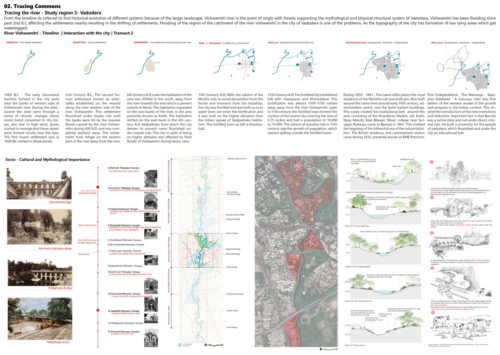
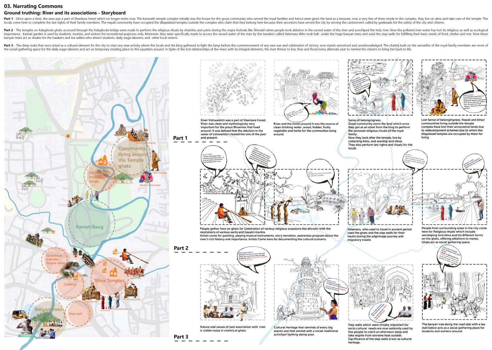
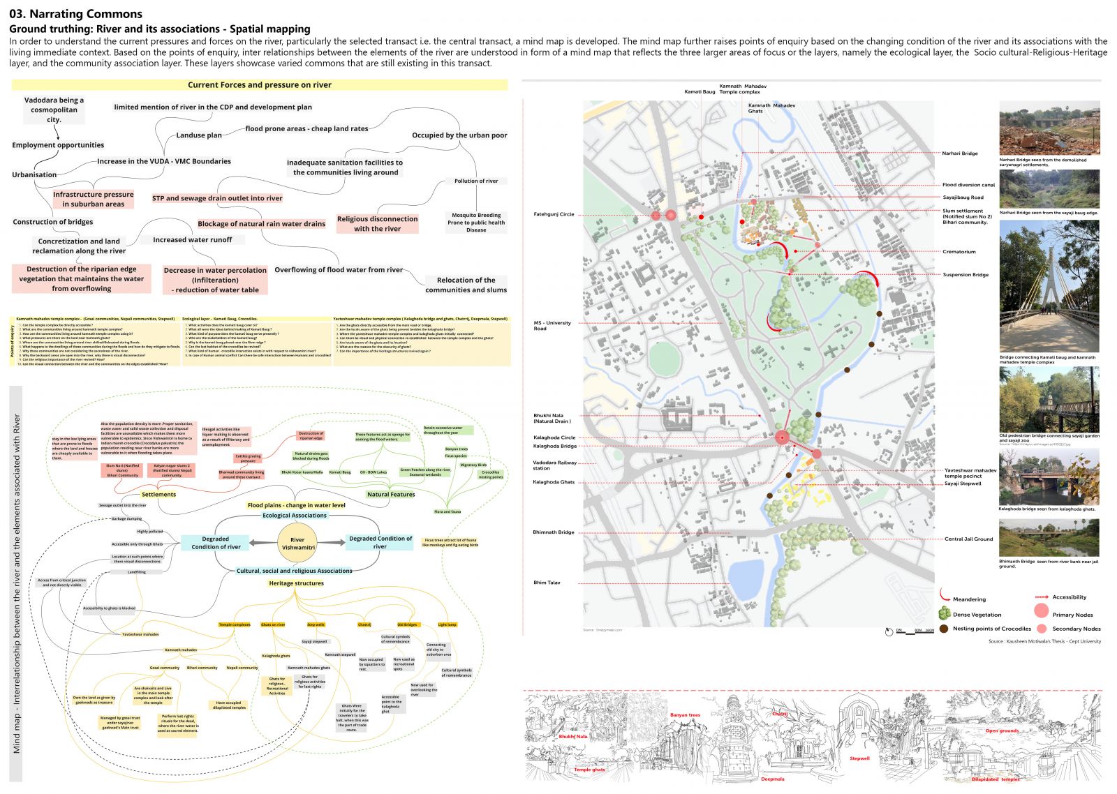
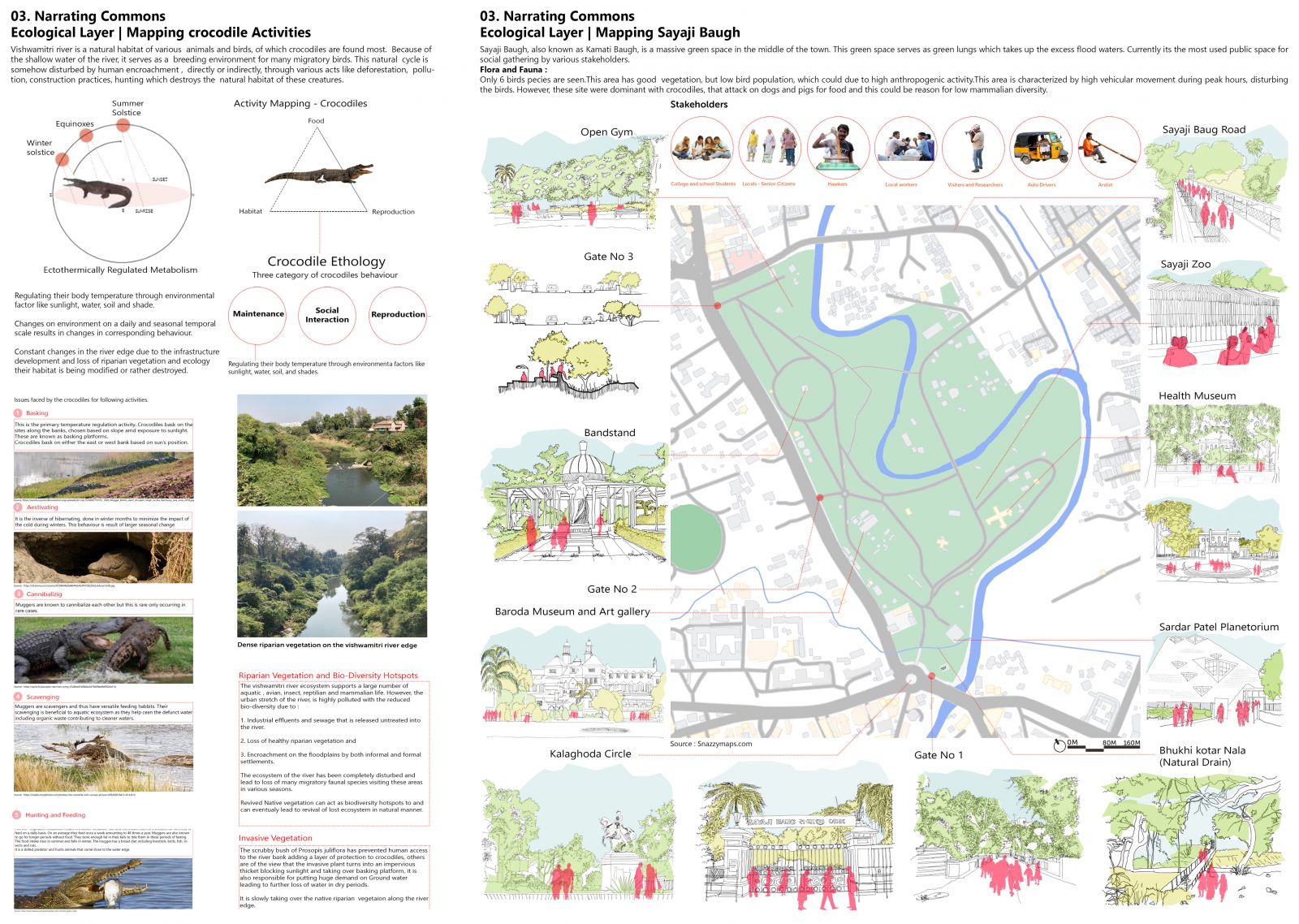
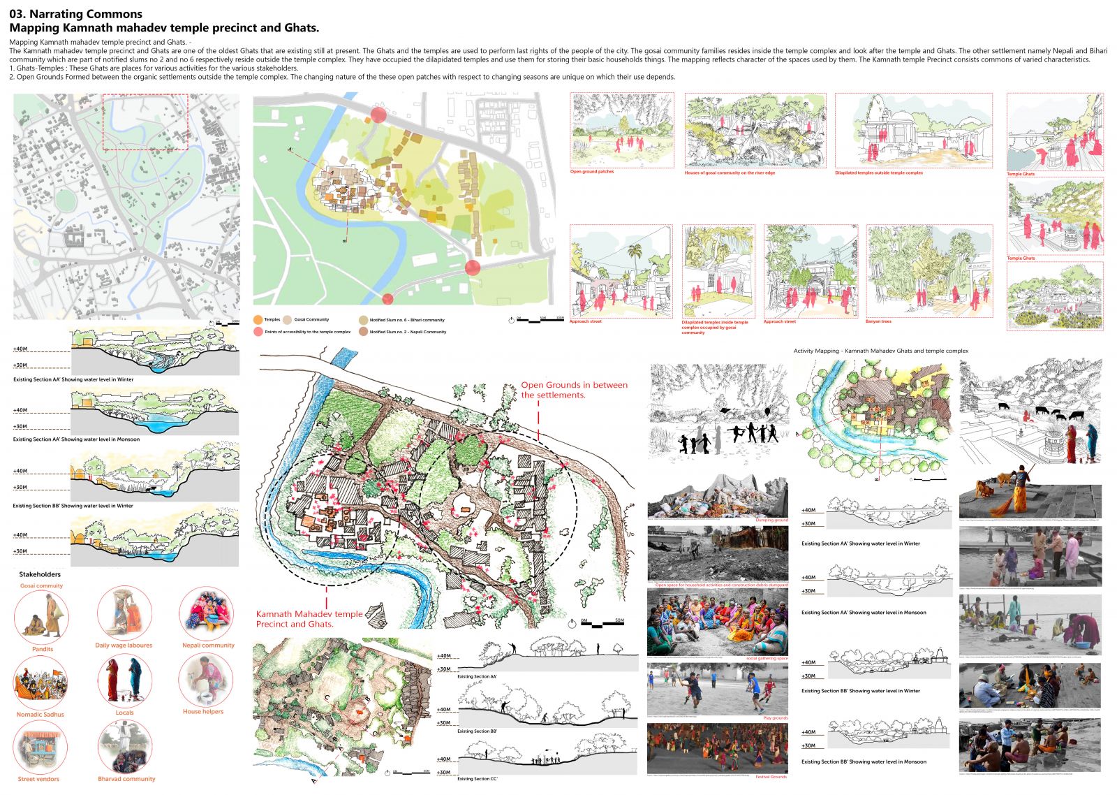
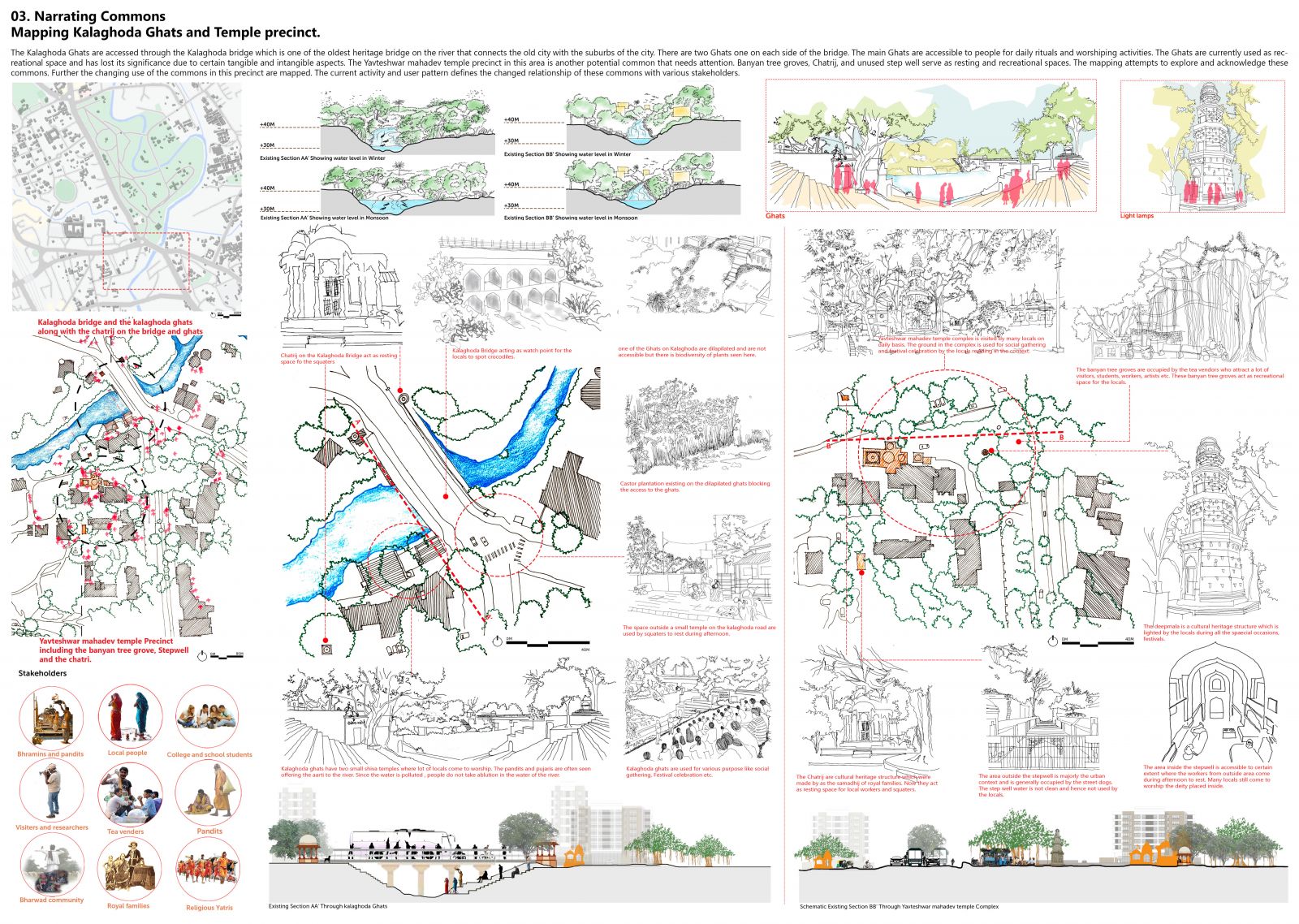
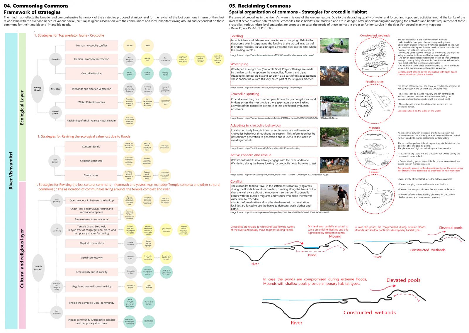
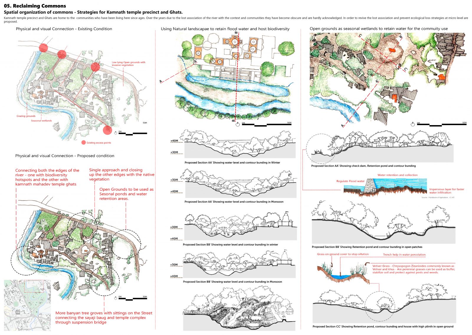
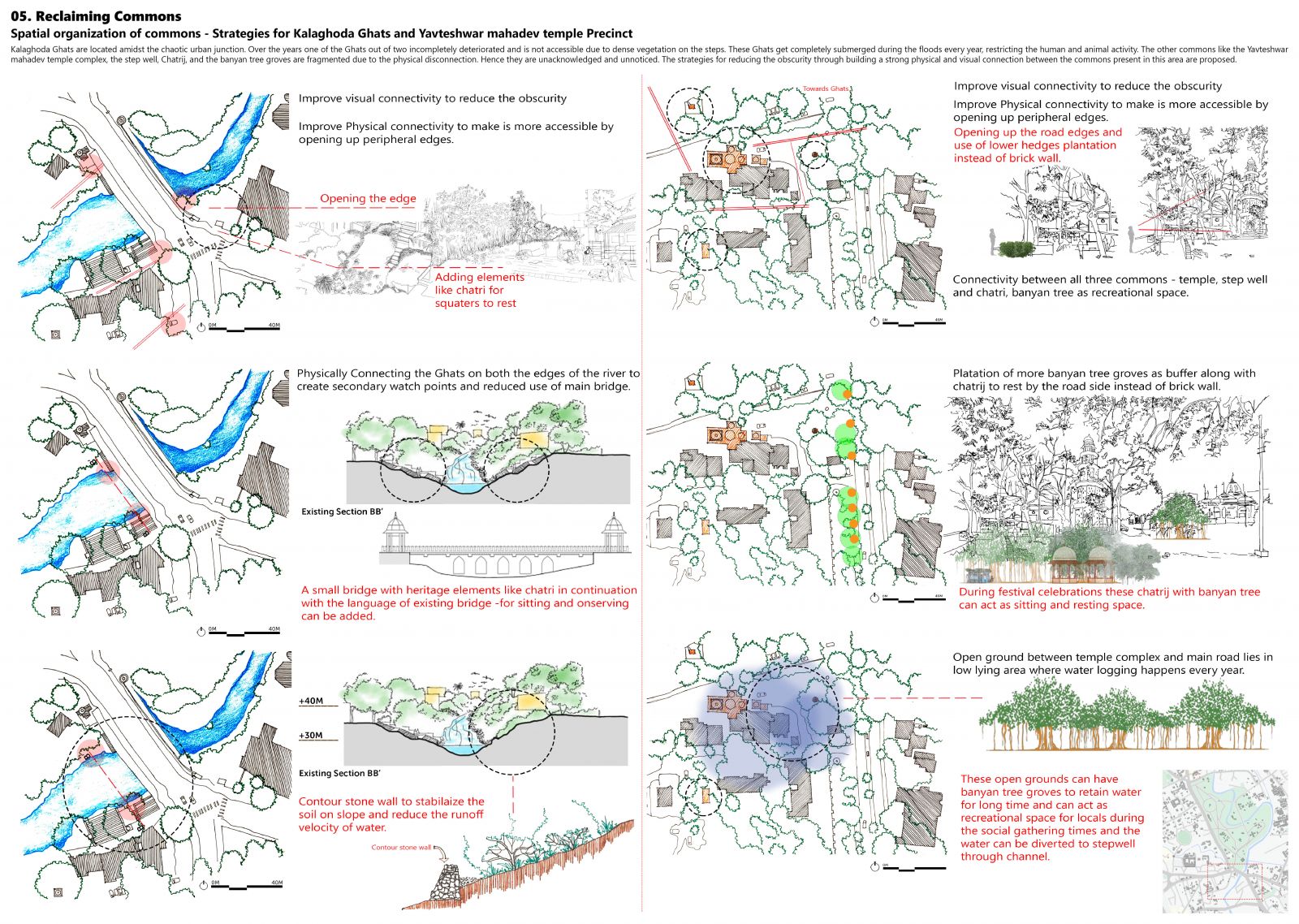
Rivers have been an integral part of human life since the prehistoric civilizations. In Indian context specifically, Rivers are considered to be holy goddess mother and hence a huge amount of population is associated with river through various reasons and relationships like socio-cultural, Mythological, Religious, livelihood etc. River Vishwamitri which originates from Pavagadh hill is one such river that flows through Vadodara dividing the city into two parts. The river has been ignored for many years and so the response to the river has declined in years, resulting in deterioration of the river. The river has been important for a very limited population who depends on the river water for their day today activities. Vishwamitri once was part of Shankara forest which no longer exists now. The cultural heritage symbols like Ghats, Chatrij, bridge, temple precincts, Light lamps etc. that once were integral part of inhabitants of Vadodara and served the locals as well as migrators, now stand unnoticed and unacknowledged. The project aims at recognizing these lost commons, acknowledge their presence and identical importance,  further propose possible strategies to revive and revitalize these lost commons.

View Additional Work

Report Content

01. Recognizing Commons | Commons as system of relationships -The Exercise reflects the understanding of the commons through various readings. The paper describes the understanding of the commons based on individual perception of the commons with suitable examples to support the same. In addition to that an Abstract graphic representing the idea of common in the paper is developed in order to relate the spatial idea of the commons.

02. Tracing Commons | Tracing the river - Study region 3- Vadodara - From the timeline its inferred to find historical evolution of different systems because of the larger landscape. Vishwamitri river is the point of origin with forests supporting the mythological and physical structural system of Baroda. Vishwamitri has been flooding since past 2nd B.C affecting the settlements nearby resulting in the shifting of settlements. Flooding of the region of the catchment of the river Vishwamitri in the city of Vadodara is one of the problems. As the topography of the city has formation of low-lying areas which get waterlogged.

03. Narrating Commons | Ground truthing: River and its associations: Storyboard - The story board reflects and narrates the voices of the stakeholders in terms of the relationships that exist, the ones that have changed over the years, and the ones which have completely vanished.

Narrating Commons | Ground truthing: River and its associations: Spatial mapping - In order to understand the current pressures and forces on the river, particularly the selected transact i.e. the central transact, a mind map is developed. The mind map further raises points of enquiry based on the changing condition of the river and its associations with the living immediate context. Based on the points of enquiry, inter relationships between the elements of the river are understood in form of a mind map that reflects the three larger areas of focus or the layers, namely the ecological layer, the Socio Cultural-Religious-Heritage layer, and the community association layer. These layers showcase varied commons that are still existing in this transact.

03. Narrating Commons | Ecological Layer | Mapping crocodile Activities - Vishwamitri river is a natural habitat of various animals and birds, of which crocodiles are found most. Because of the shallow water of the river, it serves as a breeding environment for many migratory birds. This natural cycle is somehow disturbed by human encroachment, directly or indirectly, through various acts like deforestation, pollution, construction practices, hunting which destroys the natural habitat of these creatures. 03. Narrating Commons | Ecological Layer | Mapping Sayaji Baugh - Sayaji Baugh, also known as Kamati Baugh, is a massive green space in the middle of the town. This green space serves as green lungs which takes up the excess flood waters. Currently it’s the most used public space for social gathering by various stakeholders.

03. Narrating Commons | Mapping Kamnath Mahadev temple precinct and Ghats. - The Kamnath Mahadev temple precinct and Ghats are one of the oldest Ghats that are existing still at present. The Ghats and the temples are used to perform the last rights of the people of the city. The Gosai community families resides inside the temple complex and look after the temple and Ghats. The other settlement namely Nepali and Bihari community which are part of notified slums no 2 and no 6 respectively reside outside the temple complex. They have occupied the dilapidated temples and use them for storing their basic households’ things. The mapping reflects character of the spaces used by them. The Kamnath temple Precinct consists commons of varied characteristics. 1. Ghats-Temples: These Ghats are places for various activities for the various stakeholders. 2. Open Grounds Formed between the organic settlements outside the temple complex.

03. Narrating Commons | Mapping Kalaghoda Ghats and Temple precinct - The Kalaghoda Ghats are accessed through the Kalaghoda bridge which is one of the oldest heritage bridges on the river that connects the old city with the suburbs of the city. There are two Ghats one on each side of the bridge. The main Ghats are accessible to people for daily rituals and worshiping activities. The Ghats are currently used as recreational space and has lost its significance due to certain tangible and intangible aspects. The Yavteshwar Mahadev temple precinct in this area is another potential common that needs attention. Banyan tree groves, Chattrij, and unused step well serve as resting and recreational spaces. The mapping attempts to explore and acknowledge these commons. Further the changing use of the commons in this precinct are mapped. The current activity and user pattern define the changed relationship of these commons with various stakeholders.

04. Commoning Commons | Framework of strategies - The mind map reflects the broader and comprehensive framework of the strategies proposed at micro level for the revival of the lost commons in term of their lost relationship with the river and hence its various social, cultural, religious association with the communities and local inhabitants living around and dependent on these commons for their tangible and intangible needs. 05. Reclaiming Commons | Spatial organization of commons - Strategies for crocodile Habitat - Presence of crocodiles in the river Vishwamitri is one of the unique features. Due to the degrading quality of water and forced anthropogenic activities around the banks of the river that serve as active habitat of the crocodiles, these habitats are modified and are in danger. After understanding and mapping the activities and habitat requirement of these crocodiles, various micro level strategies are proposed to cater the needs of these animals.

05. Reclaiming Commons | Spatial organization of commons - Strategies for Kamnath temple precinct and Ghats. - Kamnath temple precinct and Ghats are home to the communities who have been living here since ages. Over the years due to the lost association of the river with the context and communities they have become obscure and are hardly acknowledged. In order to revive the lost association and prevent ecological loss strategies at micro level are proposed.

05. Reclaiming Commons | Spatial organization of commons - Strategies for Kalaghoda Ghats and Yavteshwar mahadev temple Precinct - Kalaghoda Ghats are located amidst the chaotic urban junction. Over the years one of the Ghats out of two incompletely deteriorated and is not accessible due to dense vegetation on the steps. These Ghats get completely submerged during the floods every year, restricting the human and animal activity. The other commons like the Yavteshwar mahadev temple complex, the step well, Chattrij, and the banyan tree groves are fragmented due to the physical disconnection. Hence, they are unacknowledged and unnoticed. The strategies for reducing the obscurity through building a strong physical and visual connection between the commons present in this area are proposed.