Nitya Patel

UR3001

Shock Absorber for the city

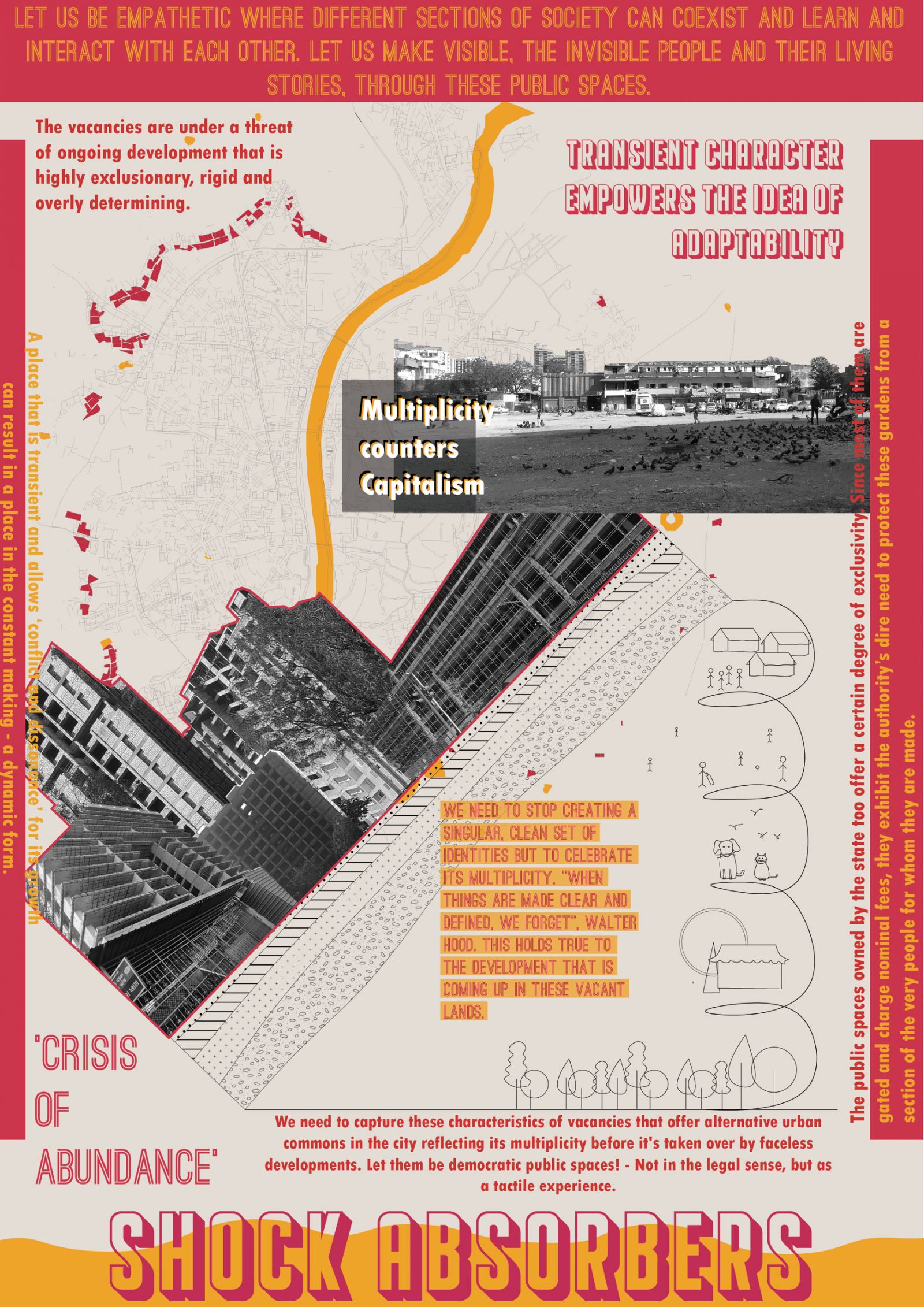
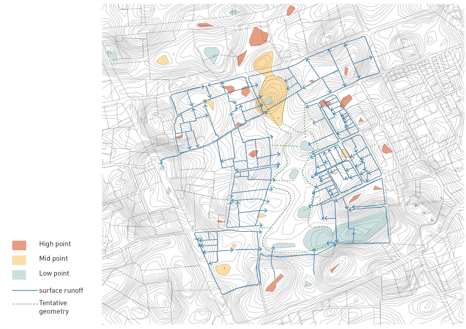
The stress of current fast-paced developments in cities have slowly led us to a point where we are looking at irreversible damage to nature resulting in larger problems of the climate that we will soon need to address. . The project demonstrates the potential in the relationship between the vacant lands and city that operates with the absorption of various urban stresses generated with heavy developments, diminished natural air and water quality, decreasing open spaces or limitations in enjoying a healthy public life. The project works in thresholds to offset each of these stresses with an empathetic approach towards the Town Planning mechanism where the natural systems are respected along with preserving the openness of the vacant spaces.

View Additional Work

Report Content

// vacant lands as as an invaluable resource for ecological and social shock absorbers // Protection of Urban Lakes // Multiplicity of uses // Transient character enabling adaptability

Through landform modifications and water system integration with the existing lake as the primary steps, the project implements a wetland system integrated with the urban lake Malav Talav on the site that would overtime generate a green infrastructure around it and resulting open spaces within The characteristics of openness of these vacant lands are captured through these indeterministic linear continuous green spaces emerging along the wetland and secondary pockets of open spaces in between the buildings.

With a permanent water infrastructure placed on the site, it allows for open spaces to remain open. Through this strategy, the openness of the vacant spaces is preserved as an accessible public space. With the reconf iguration of the Town Planning Scheme and the same amount of Public land used, the resultant outcome is an empathetic and sensitive approach towards the city’s natural systems and public life. This strategy allows remediation and protection of Urban Lakes in the city that are under threat of vanishing. Similar big open spaces in the city will be the relieving points in contrast with the dense neighbourhoods. This area of building footprint is also reduced to promote vertical development and have more open spaces on the ground.

The existing town planning scheme is proposed for public and private development. FSI 4 has been proposed for the greenbelt development due to the upcoming TOD and to accommodate the pressures of future development. Total area of the Jivraj park Greenbelt - 20ha (2,07,866sq.m) Area of lake - 1.5ha (15,325 sq.m) Area of public space around lake - 3 ha (30,745 sq.m) Area of built proposed - 16.9 ha (1,69,450 sq.m) Area of roads - 3.8 ha (38,420 sq.m) ? Total area of government plots - 7.5 ha Total area of Government owned land = 11.3 ha (1,13,042 sq. m)

The employed geometry of the wetland is derived with exaggerated modifications of the existing site level conditions to enable optimal cut and fill processes. Intervening further into this primary level geometries give rise to small pockets in between the wetlands and seasonal recharge ponds while the spaces in between remain open. These pockets are created around the lowest points of the wetland and would result in conditions that largely inhibits development in the surroundings. This site is re-imagined to take in the anticipated future shock that the city that will face arising from acute lack of large consolidated open public spaces.

Constructed wetland treats sewage water to the point that is safe, using mainly subsurface vertical flow of water. The wetland has a precautionary overflow of water. The edges have a continuous green open space as porous public space. The undulations employed to create these different edge conditions have uplands that stay dry throughout the year that can accommodate the permanent activities. Marshes restrict permanent development to be built and the seasonal recharge ponds which turn to maidan (playground) during summers and fills up during monsoons - so the users witness seasonal changes in the way these lands allow inhibition and operation.

The Wetland and the recharge points results in a certain configuration of land that is made available for development. Due to its proximity to the recharge ponds or the wetlands and not enough space for construction it remains empty. This gives people an opportunity to use and appropriate the space as they desire. Marshlands are the edges along the wetland and the built. They act as transition spaces between a recharge pond or a wetland and land otherwise. Since, the land is filled with water and quite muddy, they remain as open spaces. These become an ecotone for different species to interact and enhance the ecological diversity of the space over the years.

The uplands along the wetlands are not only a precautionary measure to control overflowing but they act as open maidans (playground). These spaces are continuous and accessible from the surrounding. They remain dry most of the year which makes them usable all year round for different activities or large gatherings, to be appropriated by the people as and when required.

Removing the concrete edge around the lake and walls to make it a natural edge. The public space is continuous and porous without any physical barrier. The vegetation on the edge is planted strategically to restrict people accessing the place at specific locations. The lake is connected to the wetland system through a channel that goes underground in case of a street passing. The lake edge is made natural with hydrophytes to revive the ecosystem of the lake. Integrating it with the wetland is a way to remediate and protect these urban lakes from further encroachment. Friendly connection to the water is introduced along the lake edge with minimal interaction by touch and the edge is made higher as a flat land so it can give space for activities of certain kind and scale to take place.

Uplands might have marshes along the edge of the wetland from keeping people from directly access the wetland. These can be used where there is a risk of toxic water or contaminated water being released in the wetland. The pathways act as a continuous walkway around the site. The undulation act as a way to break down the spaces, restrict access and guide people to usable spaces without the use of walls or fences. ?The greenbelt has only remained vacant on the west side of Ahmedabad. Town planning schemes are being made for future developments. The larger concept of shock absorbers can be reproduced at different locations from the site of Jivaraj Park with modif ications based on contextual conditions. These sites have the potential to remain open as an ecological shock absorber and also preserve open spaces as public spaces.