Mayank Gupta

UD4006

F.L.U.I.D

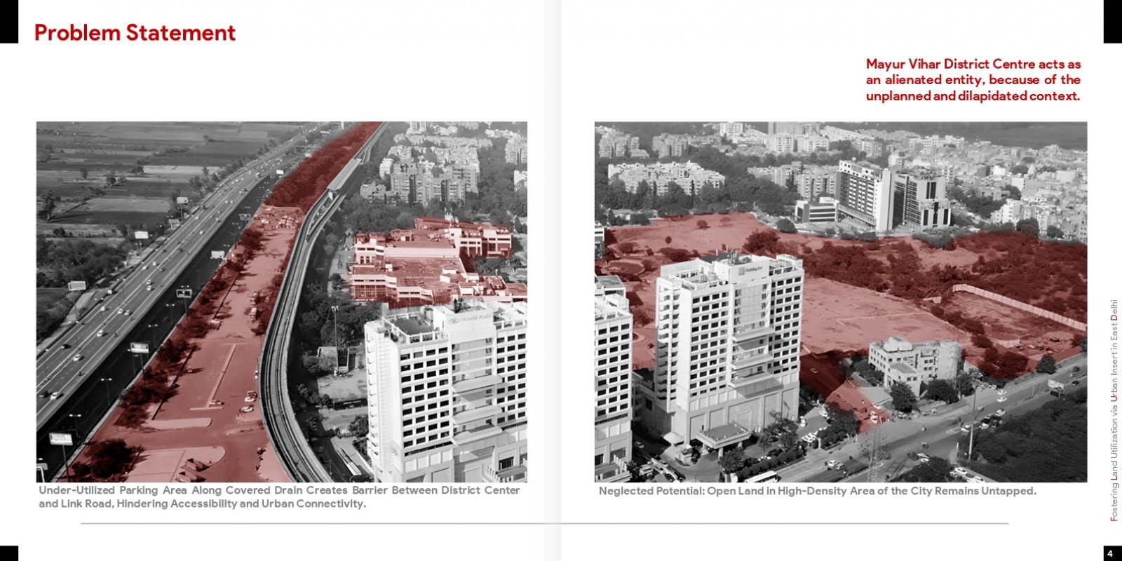
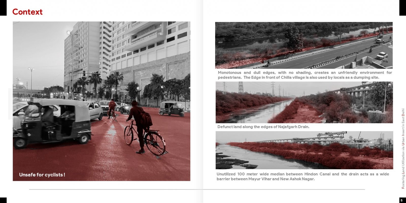
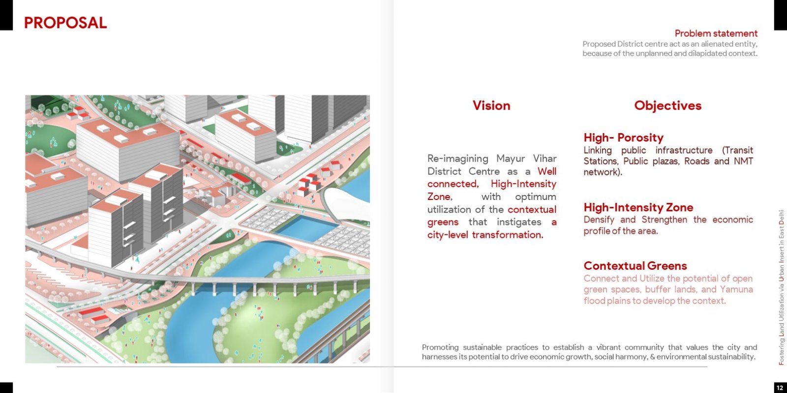
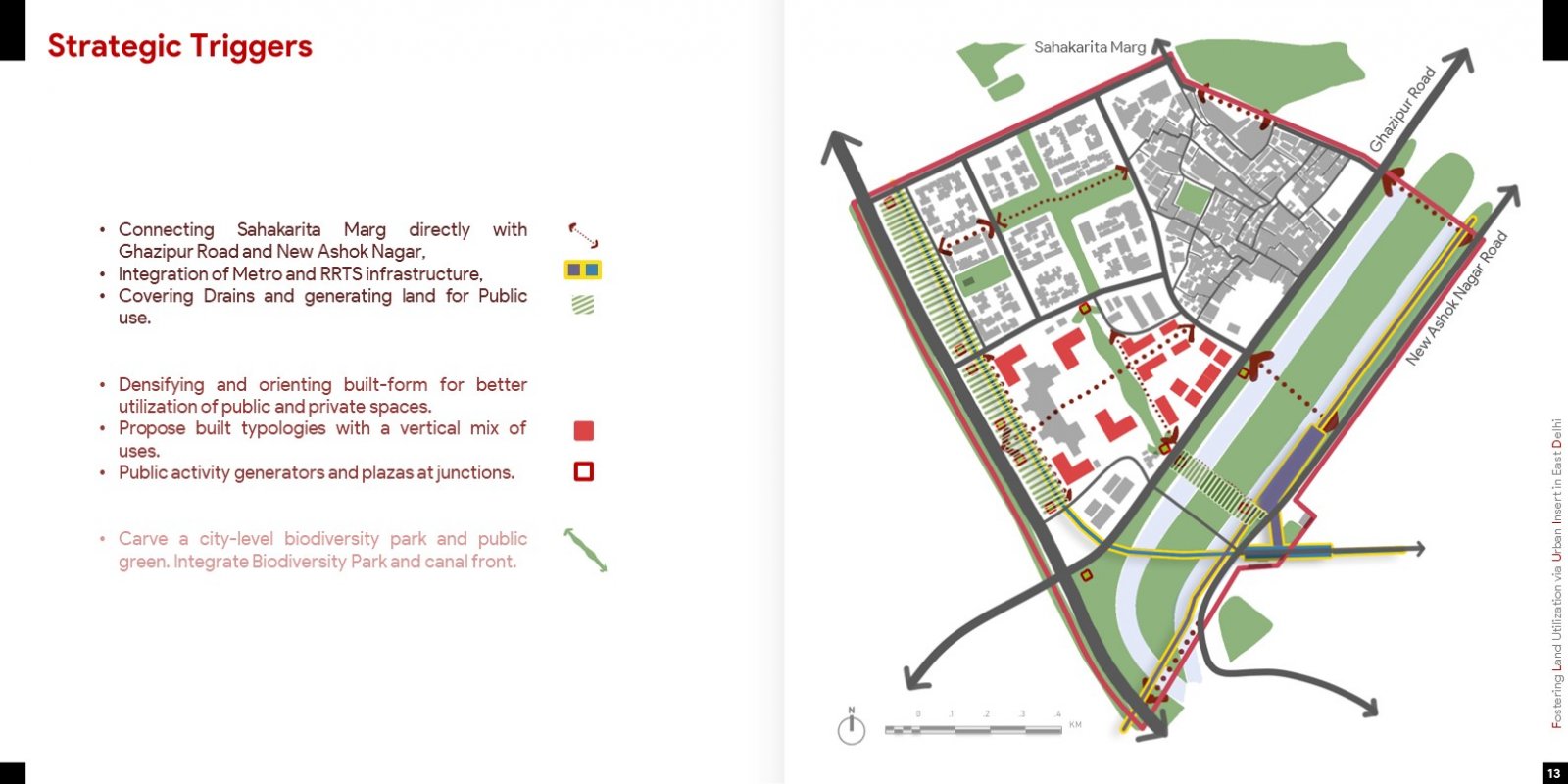
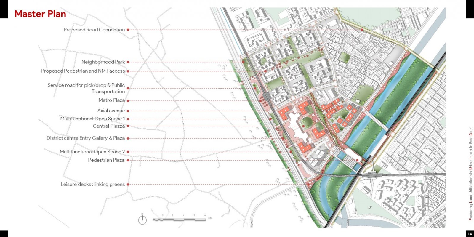
Fostering Land Utilization via Urban Insert (F.L.U.I.D) is an Urban Design Intervention in East Delhi which re-imagines Mayur Vihar District Centre as a well-connected, High-Intensity Zone, with optimum utilization of the contextual greens that instigates a city-level transformation. This is done through 3 objectives. Firstly, the District Center should prioritize high porosity, connecting public infrastructure and network links to improve accessibility and encourage sustainable transportation. It should also be a high-intensity zone that promotes economic activity through better land use planning and mixed-use development. Finally, the design focuses on contextual greens by connecting and utilizing the potential of open green spaces, buffer lands, and the Yamuna floodplains to develop the context. By promoting sustainable practices, the community can establish a vibrant environment that values the city and harnesses its potential to drive economic growth, social harmony, and environmental sustainability. 


Report Content

Mayur Vihar District Center acts as an alienated entity Mayur Vihar District Centre, is facing numerous challenges that have made it an alienated entity in the area. A thorough site analysis revealed a multitude of issues, including unsafe conditions for pedestrians and cyclists, underutilized vacant lands, defunct areas along the drain, and a lack of accessibility.

The wide roads and junctions that prioritize the needs and convenience of motor vehicles over other modes of transportation and the Sub Arterial Ghazipur Road, with its dead edge along the buffer area. A staggering 94% of the Noida-Link Arterial road is devoted to infrastructure for vehicular traffic, sandwiched between flood plains and drain buffer.

City-Level Transformation via Urban Interventions The vision for the design is to Re-imagining Mayur Vihar District Centre as a Well connected, High-Intensity Zone, with optimum utilization of the contextual greens that instigates a city-level transformation. This is done through 3 objectives. Firstly, the District Center should prioritize high-porosity, connecting public infrastructure and network links to improve accessibility and encourage sustainable transportation. It should also be a high-intensity zone that promotes economic activity through better land use planning and mixed-use development. Finally, the design must focus on contextual greens by connecting and utilizing the potential of open green spaces, buffer lands, and the Yamuna floodplains to develop the context. By promoting sustainable practices, the community can establish a vibrant environment that values the city and harnesses its potential to drive economic growth, social harmony, and environmental sustainabili

Strategic Interventions The proposal includes connecting Sahakarita Marg to Ghazipur Road and New Ashok Nagar, integrating Metro and RRTS infrastructure, covering drains to generate land for public use, densifying and orienting built-form, proposing built typologies with a vertical mix of uses, creating public activity generators and plazas at junctions, and carving a city-level biodiversity park and public green while integrating it with the canal front.

Master plan The plan includes a pedestrian plaza to capture influx from RRTS and MRTS towards the District Centre. Public spaces along the streets feature leisure decks linking greens, a multifunctional open space, an axial avenue, etc.

Proposals - Built Form The proposals retain existing structures, adding G+8 structure within the district center and a vertical mix of uses. The proposed interventions increase the Gross FAR from 120 to 300.

Isometric The 3D visualization of the master plan plays a vital role in humanizing the space by enabling a visual representation of the public realm design. It helps to showcase how the space has been enhanced and how people can utilize it for various activities. The design focuses on making the space more accessible, with visible human activities and two levels of space, including a public deck and a public arboretum.

Section through Deck To enhance public urban space and encourage activities and footfall along transit corridors, the plan suggests constructing cantilever decks along the waterfront. These decks will also serve as transportation hubs, facilitating sustainable transportation options with dedicated spaces for micro-mobility devices like bicycles and scooters, thereby reducing reliance on motor vehicles.

Section through proposed pedestrian crossover plaza. The proposed design for the 50m pedestrian plaza aims to create a welcoming and comfortable environment for visitors, featuring open public sitting areas, recreational spaces, and vending shops. Additionally, rainwater harvesting umbrellas will be strategically placed to act as an entry zone on the lower level that leads to the canal front.

The interventions focused on three key areas: Blue (River and Streets), Green (Levels of Green connecting greens of Yamuna, Hindon canal, and neighborhoods), and Grey (covering drains along link roads and opening up land for public use), intends to lead the city-level transformations.